You are here: Home > Network List > TM - Thai Seismic Monitoring Network Stations List
> Station SKLT Mueang, Songkhla > Earthquake Result Viewer
SKLT Mueang, Songkhla - Earthquake Result Viewer
| Earthquake location: |
Volcano Islands, Japan Region |
| Earthquake latitude/longitude: |
22.0/142.7 |
| Earthquake time(UTC): |
2024/02/12 (043) 11:19:36 GMT |
| Earthquake Depth: |
250 km |
| Earthquake Magnitude: |
6.1 mww |
| Earthquake Catalog/Contributor: |
NEIC PDE/us |
|
| Network: |
TM Thai Seismic Monitoring Network |
| Station: |
SKLT Mueang, Songkhla |
| Lat/Lon: |
7.18 N/100.62 E |
| Elevation: |
11 m |
|
| Distance: |
43.2 deg |
| Az: |
256.541 deg |
| Baz: |
65.423 deg |
| Ray Param: |
0.07171075 |
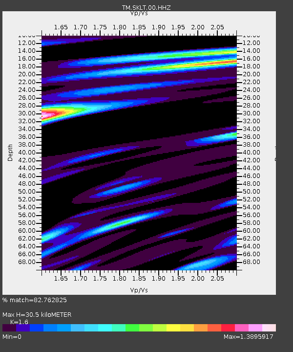
| Estimated Moho Depth: |
30.5 km |
| Estimated Crust Vp/Vs: |
1.60 |
| Assumed Crust Vp: |
6.468 km/s |
| Estimated Crust Vs: |
4.042 km/s |
| Estimated Crust Poisson's Ratio: |
0.18 |
|
| Radial Match: |
82.762825 % |
| Radial Bump: |
335 |
| Transverse Match: |
65.21131 % |
| Transverse Bump: |
362 |
| SOD ConfigId: |
33437571 |
| Insert Time: |
2024-02-26 11:43:56.242 +0000 |
| GWidth: |
2.5 |
| Max Bumps: |
400 |
| Tol: |
0.001 |
|

Signal To Noise
| Channel | StoN | STA | LTA |
| TM:SKLT:00:HHZ:20240212T11:26:42.364989Z | 10.75385 | 2.1870558E-6 | 2.0337423E-7 |
| TM:SKLT:00:HHN:20240212T11:26:42.364989Z | 3.0436523 | 6.079299E-7 | 1.9973699E-7 |
| TM:SKLT:00:HHE:20240212T11:26:42.364989Z | 6.075938 | 1.1794534E-6 | 1.9411874E-7 |
| Arrivals |
| Ps | 3.0 SECOND |
| PpPs | 11 SECOND |
| PsPs/PpSs | 14 SECOND |


