You are here: Home > Network List > TA - USArray Transportable Network (new EarthScope stations) Stations List
> Station E35A Pequot Lakes, MN, USA > Earthquake Result Viewer
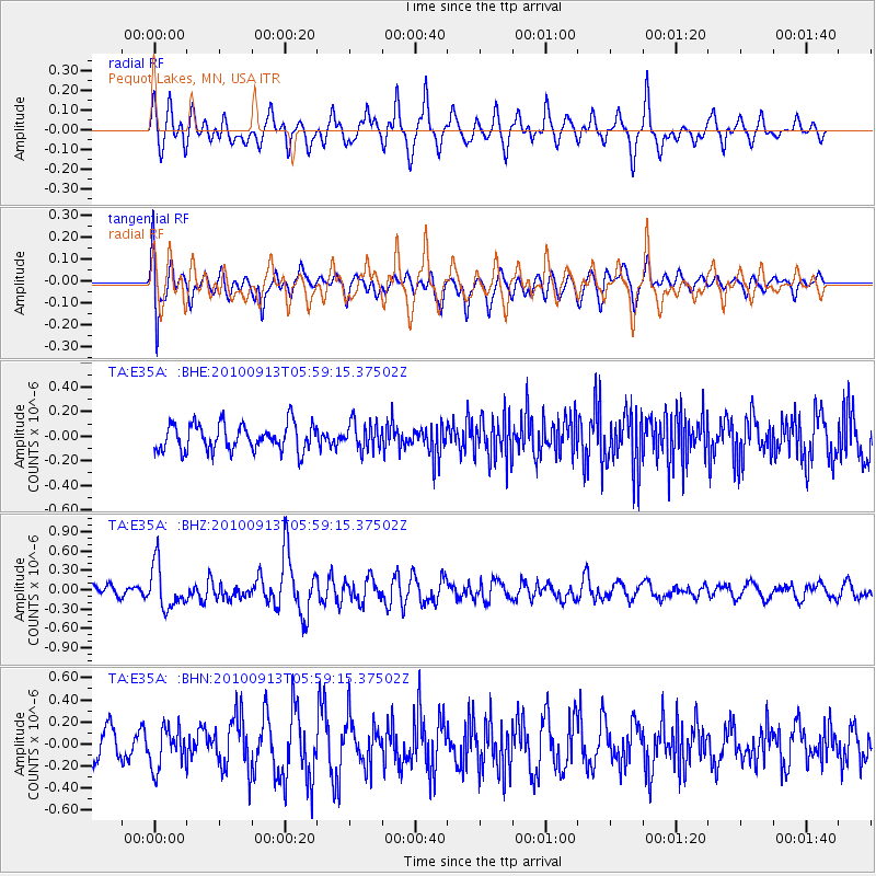
E35A Pequot Lakes, MN, USA - Earthquake Result Viewer
*The percent match for this event was below the threshold and hence no stack was calculated.
| Earthquake location: |
Hokkaido, Japan Region |
| Earthquake latitude/longitude: |
41.5/142.0 |
| Earthquake time(UTC): |
2010/09/13 (256) 05:47:48 GMT |
| Earthquake Depth: |
61 km |
| Earthquake Magnitude: |
5.8 MB, 5.8 MW, 5.8 MW |
| Earthquake Catalog/Contributor: |
WHDF/NEIC |
|
| Network: |
TA USArray Transportable Network (new EarthScope stations) |
| Station: |
E35A Pequot Lakes, MN, USA |
| Lat/Lon: |
46.56 N/94.40 W |
| Elevation: |
409 m |
|
| Distance: |
79.0 deg |
| Az: |
35.834 deg |
| Baz: |
320.405 deg |
| Ray Param: |
$rayparam |
*The percent match for this event was below the threshold and hence was not used in the summary stack. |
|
| Radial Match: |
63.201973 % |
| Radial Bump: |
385 |
| Transverse Match: |
69.027016 % |
| Transverse Bump: |
400 |
| SOD ConfigId: |
319893 |
| Insert Time: |
2011-01-20 08:20:22.301 +0000 |
| GWidth: |
2.5 |
| Max Bumps: |
400 |
| Tol: |
0.001 |
|
Signal To Noise
| Channel | StoN | STA | LTA |
| TA:E35A: :BHZ:20100913T05:59:15.37502Z | 2.355659 | 3.380694E-7 | 1.4351373E-7 |
| TA:E35A: :BHN:20100913T05:59:15.37502Z | 1.5818602 | 1.7861495E-7 | 1.12914506E-7 |
| TA:E35A: :BHE:20100913T05:59:15.37502Z | 1.0324508 | 1.12454565E-7 | 1.0892003E-7 |
| Arrivals |
| Ps | |
| PpPs | |
| PsPs/PpSs | |


