You are here: Home > Network List > UW - Pacific Northwest Regional Seismic Network Stations List
> Station HOOD Mt Hood Meadows, OR CREST BB SMO > Earthquake Result Viewer
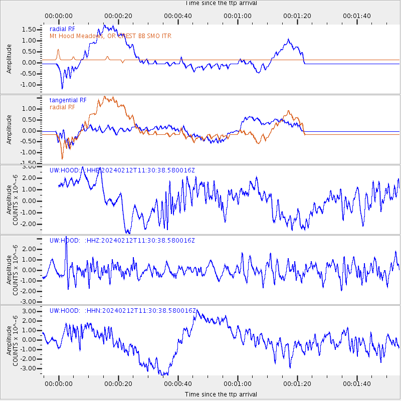
HOOD Mt Hood Meadows, OR CREST BB SMO - Earthquake Result Viewer
*The percent match for this event was below the threshold and hence no stack was calculated.
| Earthquake location: |
Volcano Islands, Japan Region |
| Earthquake latitude/longitude: |
22.0/142.7 |
| Earthquake time(UTC): |
2024/02/12 (043) 11:19:36 GMT |
| Earthquake Depth: |
250 km |
| Earthquake Magnitude: |
6.1 mww |
| Earthquake Catalog/Contributor: |
NEIC PDE/us |
|
| Network: |
UW Pacific Northwest Regional Seismic Network |
| Station: |
HOOD Mt Hood Meadows, OR CREST BB SMO |
| Lat/Lon: |
45.32 N/121.65 W |
| Elevation: |
1520 m |
|
| Distance: |
78.4 deg |
| Az: |
45.781 deg |
| Baz: |
289.516 deg |
| Ray Param: |
$rayparam |
*The percent match for this event was below the threshold and hence was not used in the summary stack. |
|
| Radial Match: |
60.005856 % |
| Radial Bump: |
400 |
| Transverse Match: |
37.789967 % |
| Transverse Bump: |
400 |
| SOD ConfigId: |
33437571 |
| Insert Time: |
2024-02-26 11:47:45.184 +0000 |
| GWidth: |
2.5 |
| Max Bumps: |
400 |
| Tol: |
0.001 |
|
Signal To Noise
| Channel | StoN | STA | LTA |
| UW:HOOD: :HHZ:20240212T11:30:38.580016Z | 2.4169486 | 9.995584E-7 | 4.1356213E-7 |
| UW:HOOD: :HHN:20240212T11:30:38.580016Z | 1.723966 | 9.1603033E-7 | 5.3135057E-7 |
| UW:HOOD: :HHE:20240212T11:30:38.580016Z | 1.4486712 | 2.1313713E-6 | 1.4712595E-6 |
| Arrivals |
| Ps | |
| PpPs | |
| PsPs/PpSs | |


