You are here: Home > Network List > US - United States National Seismic Network Stations List
> Station HAWA Hanford, Washington, USA > Earthquake Result Viewer
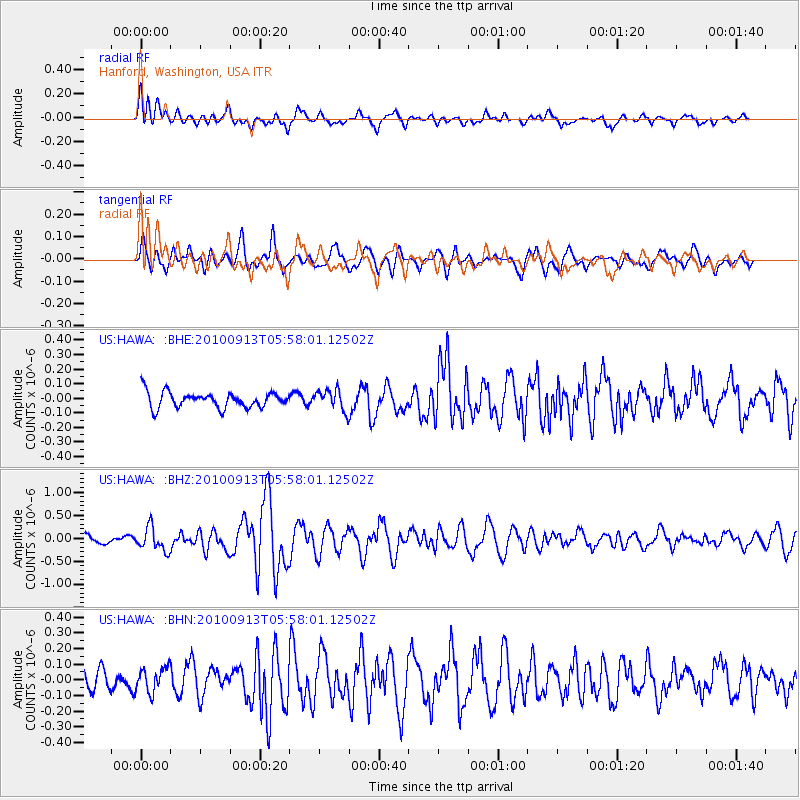
HAWA Hanford, Washington, USA - Earthquake Result Viewer
*The percent match for this event was below the threshold and hence no stack was calculated.
| Earthquake location: |
Hokkaido, Japan Region |
| Earthquake latitude/longitude: |
41.5/142.0 |
| Earthquake time(UTC): |
2010/09/13 (256) 05:47:48 GMT |
| Earthquake Depth: |
61 km |
| Earthquake Magnitude: |
5.8 MB, 5.8 MW, 5.8 MW |
| Earthquake Catalog/Contributor: |
WHDF/NEIC |
|
| Network: |
US United States National Seismic Network |
| Station: |
HAWA Hanford, Washington, USA |
| Lat/Lon: |
46.39 N/119.53 W |
| Elevation: |
364 m |
|
| Distance: |
66.4 deg |
| Az: |
48.315 deg |
| Baz: |
305.846 deg |
| Ray Param: |
$rayparam |
*The percent match for this event was below the threshold and hence was not used in the summary stack. |
|
| Radial Match: |
70.937614 % |
| Radial Bump: |
400 |
| Transverse Match: |
68.215576 % |
| Transverse Bump: |
400 |
| SOD ConfigId: |
319893 |
| Insert Time: |
2011-01-20 08:22:54.067 +0000 |
| GWidth: |
2.5 |
| Max Bumps: |
400 |
| Tol: |
0.001 |
|
Signal To Noise
| Channel | StoN | STA | LTA |
| US:HAWA: :BHZ:20100913T05:58:01.12502Z | 2.5063083 | 2.5334214E-7 | 1.0108179E-7 |
| US:HAWA: :BHN:20100913T05:58:01.12502Z | 1.3572996 | 7.85784E-8 | 5.7893192E-8 |
| US:HAWA: :BHE:20100913T05:58:01.12502Z | 1.3376534 | 7.147159E-8 | 5.3430572E-8 |
| Arrivals |
| Ps | |
| PpPs | |
| PsPs/PpSs | |


