You are here: Home > Network List > AG - Arkansas Seismic Network Stations List
> Station XB03 El Dorado Temporary Station XB03 > Earthquake Result Viewer
XB03 El Dorado Temporary Station XB03 - Earthquake Result Viewer
| Earthquake location: |
Near Coast Of Central Chile |
| Earthquake latitude/longitude: |
-28.9/-71.5 |
| Earthquake time(UTC): |
2024/02/14 (045) 01:31:41 GMT |
| Earthquake Depth: |
22 km |
| Earthquake Magnitude: |
6.0 mww |
| Earthquake Catalog/Contributor: |
NEIC PDE/us |
|
| Network: |
AG Arkansas Seismic Network |
| Station: |
XB03 El Dorado Temporary Station XB03 |
| Lat/Lon: |
36.48 N/90.87 W |
| Elevation: |
144 m |
|
| Distance: |
67.5 deg |
| Az: |
343.212 deg |
| Baz: |
161.689 deg |
| Ray Param: |
0.056872454 |
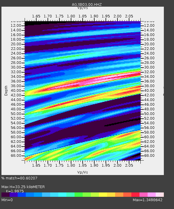
| Estimated Moho Depth: |
33.25 km |
| Estimated Crust Vp/Vs: |
2.00 |
| Assumed Crust Vp: |
6.53 km/s |
| Estimated Crust Vs: |
3.269 km/s |
| Estimated Crust Poisson's Ratio: |
0.33 |
|
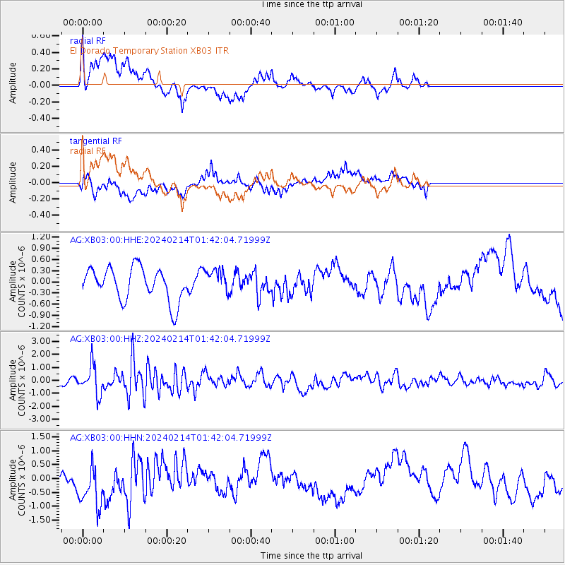
| Radial Match: |
80.60207 % |
| Radial Bump: |
257 |
| Transverse Match: |
61.673298 % |
| Transverse Bump: |
400 |
| SOD ConfigId: |
33437571 |
| Insert Time: |
2024-02-28 01:34:47.945 +0000 |
| GWidth: |
2.5 |
| Max Bumps: |
400 |
| Tol: |
0.001 |
|
Signal To Noise
| Channel | StoN | STA | LTA |
| AG:XB03:00:HHZ:20240214T01:42:04.71999Z | 3.3351898 | 1.1409419E-6 | 3.4209202E-7 |
| AG:XB03:00:HHN:20240214T01:42:04.71999Z | 2.3601556 | 8.369408E-7 | 3.5461255E-7 |
| AG:XB03:00:HHE:20240214T01:42:04.71999Z | 0.7106695 | 3.1246898E-7 | 4.3968254E-7 |
| Arrivals |
| Ps | 5.3 SECOND |
| PpPs | 15 SECOND |
| PsPs/PpSs | 20 SECOND |


