You are here: Home > Network List > UW - Pacific Northwest Regional Seismic Network Stations List
> Station MRBL Marblemount, WA, USA > Earthquake Result Viewer
MRBL Marblemount, WA, USA - Earthquake Result Viewer
| Earthquake location: |
Hokkaido, Japan Region |
| Earthquake latitude/longitude: |
41.5/142.0 |
| Earthquake time(UTC): |
2010/09/13 (256) 05:47:48 GMT |
| Earthquake Depth: |
61 km |
| Earthquake Magnitude: |
5.8 MB, 5.8 MW, 5.8 MW |
| Earthquake Catalog/Contributor: |
WHDF/NEIC |
|
| Network: |
UW Pacific Northwest Regional Seismic Network |
| Station: |
MRBL Marblemount, WA, USA |
| Lat/Lon: |
48.52 N/121.48 W |
| Elevation: |
75 m |
|
| Distance: |
64.1 deg |
| Az: |
47.229 deg |
| Baz: |
303.958 deg |
| Ray Param: |
0.058975495 |
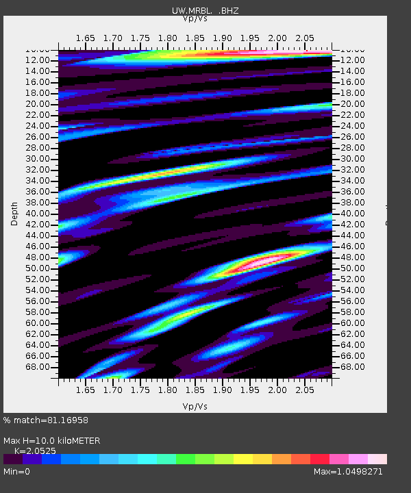
| Estimated Moho Depth: |
10.0 km |
| Estimated Crust Vp/Vs: |
2.05 |
| Assumed Crust Vp: |
6.566 km/s |
| Estimated Crust Vs: |
3.199 km/s |
| Estimated Crust Poisson's Ratio: |
0.34 |
|
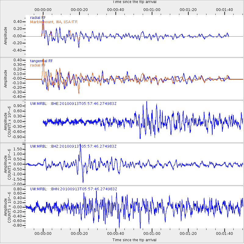
| Radial Match: |
81.16958 % |
| Radial Bump: |
400 |
| Transverse Match: |
72.53458 % |
| Transverse Bump: |
400 |
| SOD ConfigId: |
319893 |
| Insert Time: |
2011-01-20 08:25:26.181 +0000 |
| GWidth: |
2.5 |
| Max Bumps: |
400 |
| Tol: |
0.001 |
|
Signal To Noise
| Channel | StoN | STA | LTA |
| UW:MRBL: :BHZ:20100913T05:57:46.274983Z | 3.9204998 | 2.7252443E-7 | 6.951267E-8 |
| UW:MRBL: :BHN:20100913T05:57:46.274983Z | 1.4601429 | 1.2293042E-7 | 8.4190674E-8 |
| UW:MRBL: :BHE:20100913T05:57:46.274983Z | 1.5316253 | 1.4187899E-7 | 9.2632966E-8 |
| Arrivals |
| Ps | 1.7 SECOND |
| PpPs | 4.5 SECOND |
| PsPs/PpSs | 6.1 SECOND |


