You are here: Home > Network List > CI - Caltech Regional Seismic Network Stations List
> Station DGR Domenigoni Reservoir, California, USA > Earthquake Result Viewer
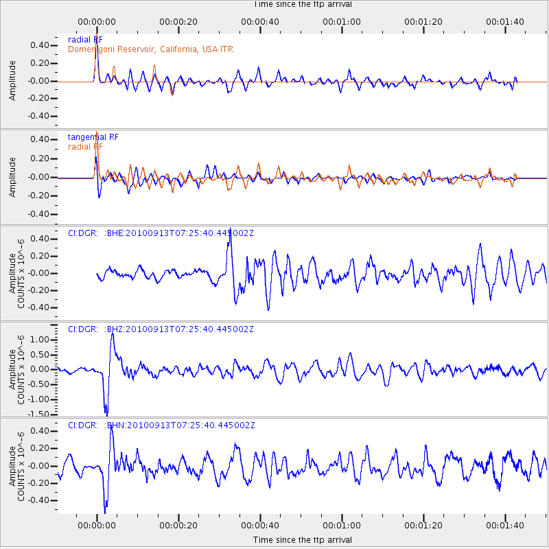
DGR Domenigoni Reservoir, California, USA - Earthquake Result Viewer
*The percent match for this event was below the threshold and hence no stack was calculated.
| Earthquake location: |
Central Peru |
| Earthquake latitude/longitude: |
-14.6/-70.8 |
| Earthquake time(UTC): |
2010/09/13 (256) 07:15:49 GMT |
| Earthquake Depth: |
180 km |
| Earthquake Magnitude: |
5.6 MB, 5.9 MW, 5.8 MW |
| Earthquake Catalog/Contributor: |
WHDF/NEIC |
|
| Network: |
CI Caltech Regional Seismic Network |
| Station: |
DGR Domenigoni Reservoir, California, USA |
| Lat/Lon: |
33.65 N/117.01 W |
| Elevation: |
609 m |
|
| Distance: |
65.1 deg |
| Az: |
318.404 deg |
| Baz: |
129.605 deg |
| Ray Param: |
$rayparam |
*The percent match for this event was below the threshold and hence was not used in the summary stack. |
|
| Radial Match: |
79.48377 % |
| Radial Bump: |
400 |
| Transverse Match: |
74.62345 % |
| Transverse Bump: |
400 |
| SOD ConfigId: |
319893 |
| Insert Time: |
2011-01-20 08:33:33.307 +0000 |
| GWidth: |
2.5 |
| Max Bumps: |
400 |
| Tol: |
0.001 |
|
Signal To Noise
| Channel | StoN | STA | LTA |
| CI:DGR: :BHZ:20100913T07:25:40.445002Z | 10.105368 | 7.5442875E-7 | 7.465624E-8 |
| CI:DGR: :BHN:20100913T07:25:40.445002Z | 3.6631548 | 2.540816E-7 | 6.936142E-8 |
| CI:DGR: :BHE:20100913T07:25:40.445002Z | 5.3160443 | 2.2692016E-7 | 4.2685905E-8 |
| Arrivals |
| Ps | |
| PpPs | |
| PsPs/PpSs | |


