You are here: Home > Network List > UW - Pacific Northwest Regional Seismic Network Stations List
> Station GNW Green Mountain (BB) > Earthquake Result Viewer
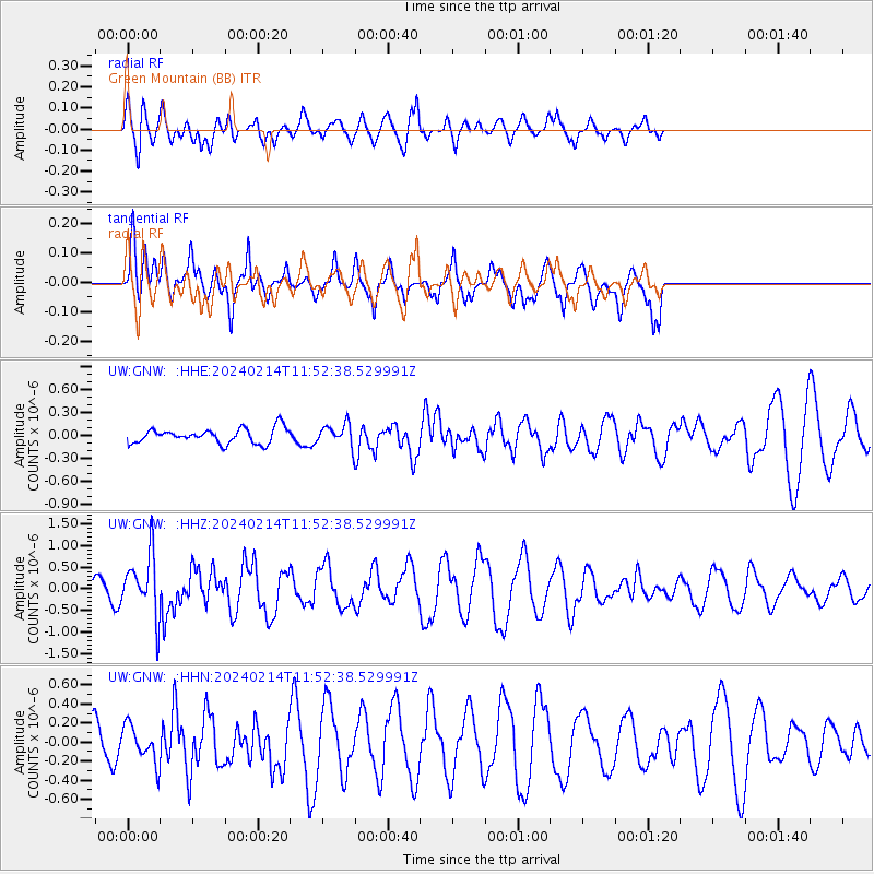
GNW Green Mountain (BB) - Earthquake Result Viewer
*The percent match for this event was below the threshold and hence no stack was calculated.
| Earthquake location: |
W. Caroline Islands, Micronesia |
| Earthquake latitude/longitude: |
11.0/138.6 |
| Earthquake time(UTC): |
2024/02/14 (045) 11:40:21 GMT |
| Earthquake Depth: |
10 km |
| Earthquake Magnitude: |
6.0 mww |
| Earthquake Catalog/Contributor: |
NEIC PDE/us |
|
| Network: |
UW Pacific Northwest Regional Seismic Network |
| Station: |
GNW Green Mountain (BB) |
| Lat/Lon: |
47.56 N/122.83 W |
| Elevation: |
160 m |
|
| Distance: |
87.7 deg |
| Az: |
42.084 deg |
| Baz: |
283.658 deg |
| Ray Param: |
$rayparam |
*The percent match for this event was below the threshold and hence was not used in the summary stack. |
|
| Radial Match: |
65.62087 % |
| Radial Bump: |
400 |
| Transverse Match: |
37.263092 % |
| Transverse Bump: |
365 |
| SOD ConfigId: |
33437571 |
| Insert Time: |
2024-02-28 12:01:13.938 +0000 |
| GWidth: |
2.5 |
| Max Bumps: |
400 |
| Tol: |
0.001 |
|
Signal To Noise
| Channel | StoN | STA | LTA |
| UW:GNW: :HHZ:20240214T11:52:38.529991Z | 1.7896348 | 7.0233534E-7 | 3.9244617E-7 |
| UW:GNW: :HHN:20240214T11:52:38.529991Z | 0.55520993 | 1.8935164E-7 | 3.4104514E-7 |
| UW:GNW: :HHE:20240214T11:52:38.529991Z | 1.4047941 | 1.3722499E-7 | 9.768335E-8 |
| Arrivals |
| Ps | |
| PpPs | |
| PsPs/PpSs | |


