You are here: Home > Network List > TA - USArray Transportable Network (new EarthScope stations) Stations List
> Station Q24A Divide, CO, USA > Earthquake Result Viewer
Q24A Divide, CO, USA - Earthquake Result Viewer
| Earthquake location: |
Central Peru |
| Earthquake latitude/longitude: |
-14.6/-70.8 |
| Earthquake time(UTC): |
2010/09/13 (256) 07:15:49 GMT |
| Earthquake Depth: |
180 km |
| Earthquake Magnitude: |
5.6 MB, 5.9 MW, 5.8 MW |
| Earthquake Catalog/Contributor: |
WHDF/NEIC |
|
| Network: |
TA USArray Transportable Network (new EarthScope stations) |
| Station: |
Q24A Divide, CO, USA |
| Lat/Lon: |
38.96 N/105.15 W |
| Elevation: |
2775 m |
|
| Distance: |
62.2 deg |
| Az: |
330.17 deg |
| Baz: |
141.853 deg |
| Ray Param: |
0.059815846 |
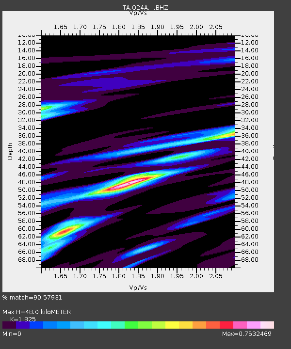
| Estimated Moho Depth: |
48.0 km |
| Estimated Crust Vp/Vs: |
1.83 |
| Assumed Crust Vp: |
6.159 km/s |
| Estimated Crust Vs: |
3.375 km/s |
| Estimated Crust Poisson's Ratio: |
0.29 |
|
| Radial Match: |
90.57931 % |
| Radial Bump: |
367 |
| Transverse Match: |
70.9348 % |
| Transverse Bump: |
362 |
| SOD ConfigId: |
319893 |
| Insert Time: |
2011-01-20 08:42:06.907 +0000 |
| GWidth: |
2.5 |
| Max Bumps: |
400 |
| Tol: |
0.001 |
|
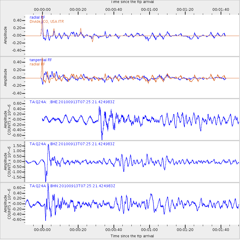
Signal To Noise
| Channel | StoN | STA | LTA |
| TA:Q24A: :BHZ:20100913T07:25:21.424983Z | 9.051286 | 8.332874E-7 | 9.206288E-8 |
| TA:Q24A: :BHN:20100913T07:25:21.424983Z | 2.925794 | 2.8350476E-7 | 9.6898404E-8 |
| TA:Q24A: :BHE:20100913T07:25:21.424983Z | 3.5878956 | 2.960662E-7 | 8.2518056E-8 |
| Arrivals |
| Ps | 6.7 SECOND |
| PpPs | 21 SECOND |
| PsPs/PpSs | 28 SECOND |


