You are here: Home > Network List > TA - USArray Transportable Network (new EarthScope stations) Stations List
> Station M26A McRoberts Ranch, Bridgeport, NE, USA > Earthquake Result Viewer
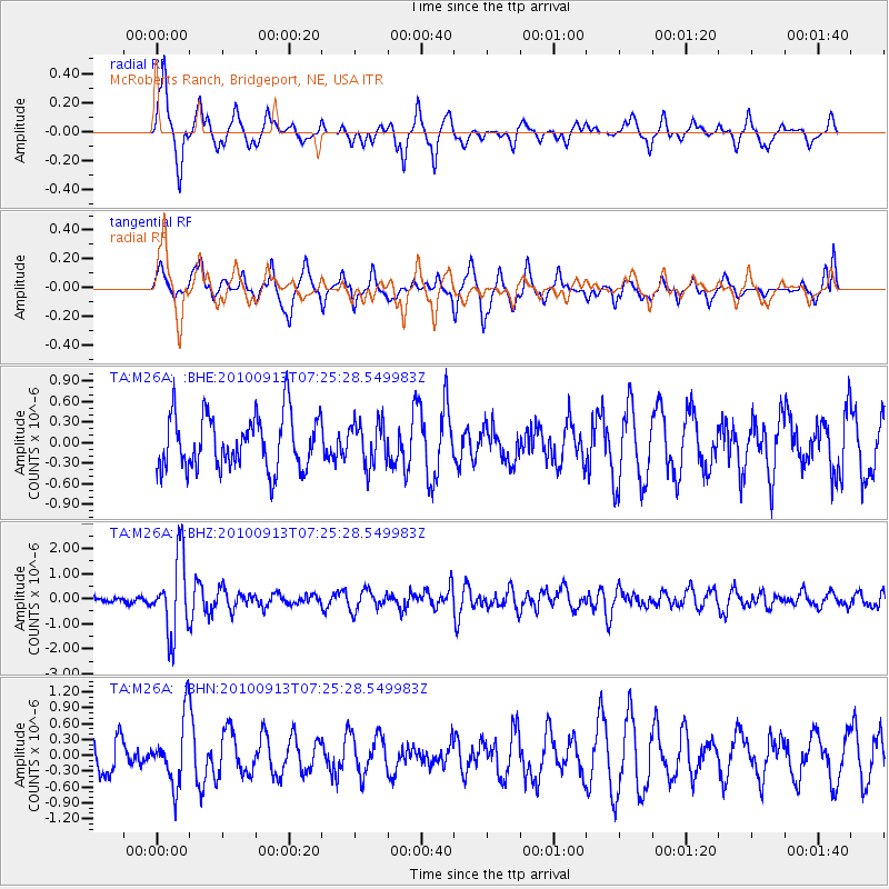
M26A McRoberts Ranch, Bridgeport, NE, USA - Earthquake Result Viewer
*The percent match for this event was below the threshold and hence no stack was calculated.
| Earthquake location: |
Central Peru |
| Earthquake latitude/longitude: |
-14.6/-70.8 |
| Earthquake time(UTC): |
2010/09/13 (256) 07:15:49 GMT |
| Earthquake Depth: |
180 km |
| Earthquake Magnitude: |
5.6 MB, 5.9 MW, 5.8 MW |
| Earthquake Catalog/Contributor: |
WHDF/NEIC |
|
| Network: |
TA USArray Transportable Network (new EarthScope stations) |
| Station: |
M26A McRoberts Ranch, Bridgeport, NE, USA |
| Lat/Lon: |
41.47 N/103.14 W |
| Elevation: |
1348 m |
|
| Distance: |
63.3 deg |
| Az: |
333.237 deg |
| Baz: |
144.548 deg |
| Ray Param: |
$rayparam |
*The percent match for this event was below the threshold and hence was not used in the summary stack. |
|
| Radial Match: |
79.17641 % |
| Radial Bump: |
374 |
| Transverse Match: |
51.203632 % |
| Transverse Bump: |
374 |
| SOD ConfigId: |
319893 |
| Insert Time: |
2011-01-20 08:44:30.342 +0000 |
| GWidth: |
2.5 |
| Max Bumps: |
400 |
| Tol: |
0.001 |
|
Signal To Noise
| Channel | StoN | STA | LTA |
| TA:M26A: :BHZ:20100913T07:25:28.549983Z | 7.6177144 | 1.4998488E-6 | 1.9688962E-7 |
| TA:M26A: :BHN:20100913T07:25:28.549983Z | 2.1992452 | 6.15714E-7 | 2.7996603E-7 |
| TA:M26A: :BHE:20100913T07:25:28.549983Z | 0.80916256 | 3.1704448E-7 | 3.9181802E-7 |
| Arrivals |
| Ps | |
| PpPs | |
| PsPs/PpSs | |


