You are here: Home > Network List > TA - USArray Transportable Network (new EarthScope stations) Stations List
> Station O27A Beecher Island, Eckley, CO, USA > Earthquake Result Viewer
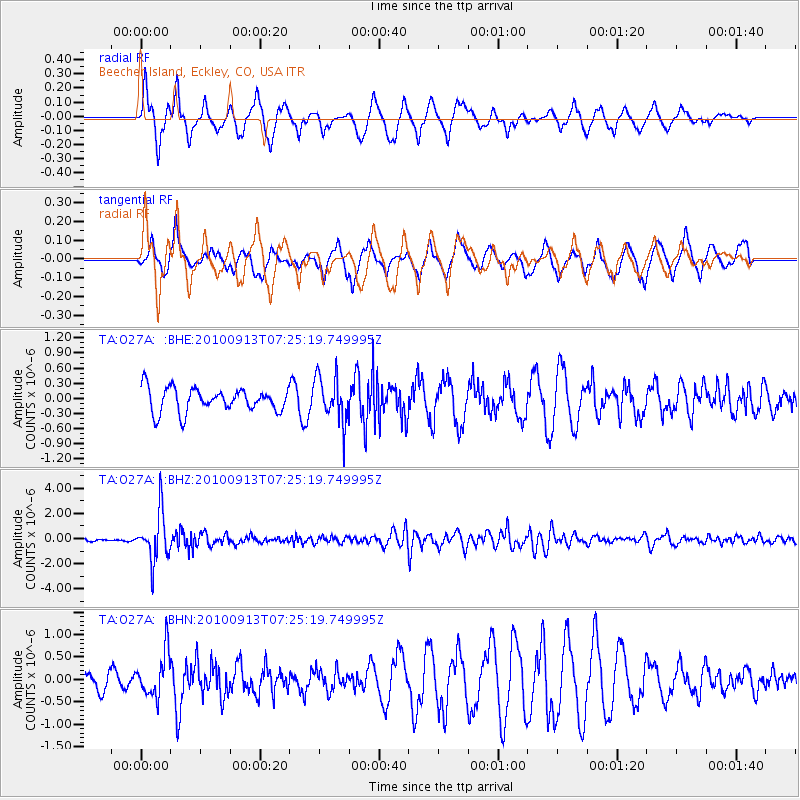
O27A Beecher Island, Eckley, CO, USA - Earthquake Result Viewer
*The percent match for this event was below the threshold and hence no stack was calculated.
| Earthquake location: |
Central Peru |
| Earthquake latitude/longitude: |
-14.6/-70.8 |
| Earthquake time(UTC): |
2010/09/13 (256) 07:15:49 GMT |
| Earthquake Depth: |
180 km |
| Earthquake Magnitude: |
5.6 MB, 5.9 MW, 5.8 MW |
| Earthquake Catalog/Contributor: |
WHDF/NEIC |
|
| Network: |
TA USArray Transportable Network (new EarthScope stations) |
| Station: |
O27A Beecher Island, Eckley, CO, USA |
| Lat/Lon: |
40.19 N/102.48 W |
| Elevation: |
1206 m |
|
| Distance: |
62.0 deg |
| Az: |
332.87 deg |
| Baz: |
144.811 deg |
| Ray Param: |
$rayparam |
*The percent match for this event was below the threshold and hence was not used in the summary stack. |
|
| Radial Match: |
74.36566 % |
| Radial Bump: |
372 |
| Transverse Match: |
56.11991 % |
| Transverse Bump: |
374 |
| SOD ConfigId: |
319893 |
| Insert Time: |
2011-01-20 08:44:41.370 +0000 |
| GWidth: |
2.5 |
| Max Bumps: |
400 |
| Tol: |
0.001 |
|
Signal To Noise
| Channel | StoN | STA | LTA |
| TA:O27A: :BHZ:20100913T07:25:19.749995Z | 19.475248 | 1.893856E-6 | 9.724425E-8 |
| TA:O27A: :BHN:20100913T07:25:19.749995Z | 1.8356318 | 4.9111503E-7 | 2.675455E-7 |
| TA:O27A: :BHE:20100913T07:25:19.749995Z | 1.934341 | 4.5352894E-7 | 2.3446174E-7 |
| Arrivals |
| Ps | |
| PpPs | |
| PsPs/PpSs | |


