You are here: Home > Network List > TA - USArray Transportable Network (new EarthScope stations) Stations List
> Station N26A Koester Ranch, Padroni, CO, USA > Earthquake Result Viewer
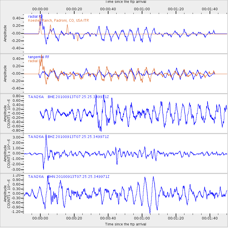
N26A Koester Ranch, Padroni, CO, USA - Earthquake Result Viewer

| Earthquake location: |
Central Peru |
| Earthquake latitude/longitude: |
-14.6/-70.8 |
| Earthquake time(UTC): |
2010/09/13 (256) 07:15:49 GMT |
| Earthquake Depth: |
180 km |
| Earthquake Magnitude: |
5.6 MB, 5.9 MW, 5.8 MW |
| Earthquake Catalog/Contributor: |
WHDF/NEIC |
|
| Network: |
TA USArray Transportable Network (new EarthScope stations) |
| Station: |
N26A Koester Ranch, Padroni, CO, USA |
| Lat/Lon: |
40.83 N/103.22 W |
| Elevation: |
1284 m |
|
| Distance: |
62.8 deg |
| Az: |
332.767 deg |
| Baz: |
144.283 deg |
| Ray Param: |
0.059433203 |
| Estimated Moho Depth: |
22.0 km |
| Estimated Crust Vp/Vs: |
1.65 |
| Assumed Crust Vp: |
6.483 km/s |
| Estimated Crust Vs: |
3.917 km/s |
| Estimated Crust Poisson's Ratio: |
0.21 |
|
| Radial Match: |
81.483635 % |
| Radial Bump: |
400 |
| Transverse Match: |
49.80771 % |
| Transverse Bump: |
338 |
| SOD ConfigId: |
319893 |
| Insert Time: |
2011-01-20 08:44:41.698 +0000 |
| GWidth: |
2.5 |
| Max Bumps: |
400 |
| Tol: |
0.001 |
|
Signal To Noise
| Channel | StoN | STA | LTA |
| TA:N26A: :BHZ:20100913T07:25:25.349971Z | 12.697684 | 1.438648E-6 | 1.1330003E-7 |
| TA:N26A: :BHN:20100913T07:25:25.349971Z | 3.7610822 | 5.5349807E-7 | 1.4716458E-7 |
| TA:N26A: :BHE:20100913T07:25:25.349971Z | 2.2849739 | 3.3872294E-7 | 1.482393E-7 |
| Arrivals |
| Ps | 2.3 SECOND |
| PpPs | 8.6 SECOND |
| PsPs/PpSs | 11 SECOND |


