You are here: Home > Network List > TA - USArray Transportable Network (new EarthScope stations) Stations List
> Station R27A Eads, CO, USA > Earthquake Result Viewer
R27A Eads, CO, USA - Earthquake Result Viewer

| Earthquake location: |
Central Peru |
| Earthquake latitude/longitude: |
-14.6/-70.8 |
| Earthquake time(UTC): |
2010/09/13 (256) 07:15:49 GMT |
| Earthquake Depth: |
180 km |
| Earthquake Magnitude: |
5.6 MB, 5.9 MW, 5.8 MW |
| Earthquake Catalog/Contributor: |
WHDF/NEIC |
|
| Network: |
TA USArray Transportable Network (new EarthScope stations) |
| Station: |
R27A Eads, CO, USA |
| Lat/Lon: |
38.29 N/102.80 W |
| Elevation: |
1201 m |
|
| Distance: |
60.6 deg |
| Az: |
331.377 deg |
| Baz: |
143.893 deg |
| Ray Param: |
0.06087364 |
| Estimated Moho Depth: |
68.75 km |
| Estimated Crust Vp/Vs: |
1.77 |
| Assumed Crust Vp: |
6.242 km/s |
| Estimated Crust Vs: |
3.517 km/s |
| Estimated Crust Poisson's Ratio: |
0.27 |
|
| Radial Match: |
88.01073 % |
| Radial Bump: |
400 |
| Transverse Match: |
56.38207 % |
| Transverse Bump: |
344 |
| SOD ConfigId: |
319893 |
| Insert Time: |
2011-01-20 08:44:52.385 +0000 |
| GWidth: |
2.5 |
| Max Bumps: |
400 |
| Tol: |
0.001 |
|
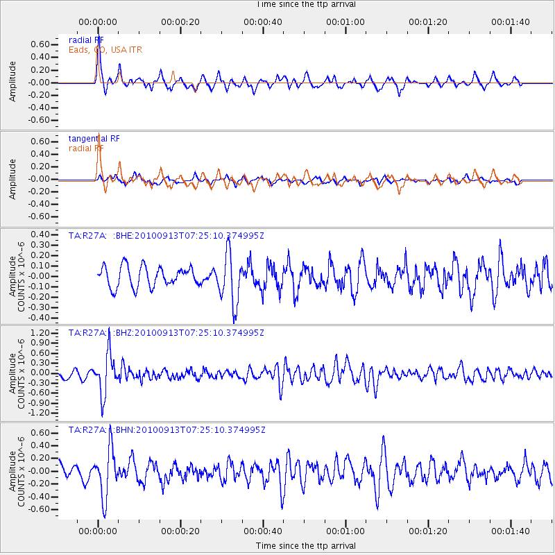
Signal To Noise
| Channel | StoN | STA | LTA |
| TA:R27A: :BHZ:20100913T07:25:10.374995Z | 7.11557 | 6.2217003E-7 | 8.743783E-8 |
| TA:R27A: :BHN:20100913T07:25:10.374995Z | 5.166821 | 3.8499599E-7 | 7.4513125E-8 |
| TA:R27A: :BHE:20100913T07:25:10.374995Z | 2.550204 | 2.4821432E-7 | 9.733116E-8 |
| Arrivals |
| Ps | 8.9 SECOND |
| PpPs | 29 SECOND |
| PsPs/PpSs | 38 SECOND |


