You are here: Home > Network List > TA - USArray Transportable Network (new EarthScope stations) Stations List
> Station 429A Davenport Ranch, Sheffield, TX, USA > Earthquake Result Viewer
429A Davenport Ranch, Sheffield, TX, USA - Earthquake Result Viewer

| Earthquake location: |
Central Peru |
| Earthquake latitude/longitude: |
-14.6/-70.8 |
| Earthquake time(UTC): |
2010/09/13 (256) 07:15:49 GMT |
| Earthquake Depth: |
180 km |
| Earthquake Magnitude: |
5.6 MB, 5.9 MW, 5.8 MW |
| Earthquake Catalog/Contributor: |
WHDF/NEIC |
|
| Network: |
TA USArray Transportable Network (new EarthScope stations) |
| Station: |
429A Davenport Ranch, Sheffield, TX, USA |
| Lat/Lon: |
30.62 N/101.89 W |
| Elevation: |
804 m |
|
| Distance: |
54.0 deg |
| Az: |
326.604 deg |
| Baz: |
141.82 deg |
| Ray Param: |
0.06510357 |
| Estimated Moho Depth: |
46.75 km |
| Estimated Crust Vp/Vs: |
1.75 |
| Assumed Crust Vp: |
6.38 km/s |
| Estimated Crust Vs: |
3.646 km/s |
| Estimated Crust Poisson's Ratio: |
0.26 |
|
| Radial Match: |
85.06121 % |
| Radial Bump: |
400 |
| Transverse Match: |
72.22484 % |
| Transverse Bump: |
400 |
| SOD ConfigId: |
319893 |
| Insert Time: |
2011-01-20 08:46:52.069 +0000 |
| GWidth: |
2.5 |
| Max Bumps: |
400 |
| Tol: |
0.001 |
|
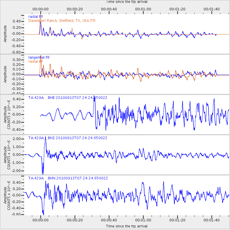
Signal To Noise
| Channel | StoN | STA | LTA |
| TA:429A: :BHZ:20100913T07:24:24.65002Z | 14.060742 | 1.1250814E-6 | 8.0015795E-8 |
| TA:429A: :BHN:20100913T07:24:24.65002Z | 2.3636057 | 2.8008836E-7 | 1.18500445E-7 |
| TA:429A: :BHE:20100913T07:24:24.65002Z | 3.233305 | 2.3906026E-7 | 7.39368E-8 |
| Arrivals |
| Ps | 5.8 SECOND |
| PpPs | 19 SECOND |
| PsPs/PpSs | 25 SECOND |


