You are here: Home > Network List > TA - USArray Transportable Network (new EarthScope stations) Stations List
> Station 531A Rocksprings, TX, USA > Earthquake Result Viewer
531A Rocksprings, TX, USA - Earthquake Result Viewer
| Earthquake location: |
Central Peru |
| Earthquake latitude/longitude: |
-14.6/-70.8 |
| Earthquake time(UTC): |
2010/09/13 (256) 07:15:49 GMT |
| Earthquake Depth: |
180 km |
| Earthquake Magnitude: |
5.6 MB, 5.9 MW, 5.8 MW |
| Earthquake Catalog/Contributor: |
WHDF/NEIC |
|
| Network: |
TA USArray Transportable Network (new EarthScope stations) |
| Station: |
531A Rocksprings, TX, USA |
| Lat/Lon: |
30.16 N/100.55 W |
| Elevation: |
661 m |
|
| Distance: |
53.0 deg |
| Az: |
327.403 deg |
| Baz: |
142.973 deg |
| Ray Param: |
0.06578313 |
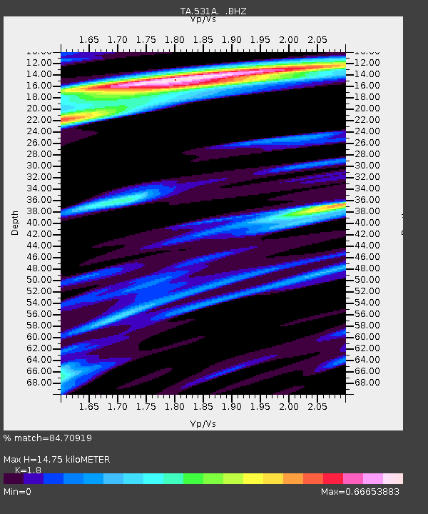
| Estimated Moho Depth: |
14.75 km |
| Estimated Crust Vp/Vs: |
1.80 |
| Assumed Crust Vp: |
6.38 km/s |
| Estimated Crust Vs: |
3.545 km/s |
| Estimated Crust Poisson's Ratio: |
0.28 |
|
| Radial Match: |
84.70919 % |
| Radial Bump: |
400 |
| Transverse Match: |
67.92098 % |
| Transverse Bump: |
400 |
| SOD ConfigId: |
319893 |
| Insert Time: |
2011-01-20 08:47:04.557 +0000 |
| GWidth: |
2.5 |
| Max Bumps: |
400 |
| Tol: |
0.001 |
|

Signal To Noise
| Channel | StoN | STA | LTA |
| TA:531A: :BHZ:20100913T07:24:16.850001Z | 12.32374 | 1.3795473E-6 | 1.11942256E-7 |
| TA:531A: :BHN:20100913T07:24:16.850001Z | 6.7023473 | 4.3998782E-7 | 6.564682E-8 |
| TA:531A: :BHE:20100913T07:24:16.850001Z | 5.230257 | 3.1614573E-7 | 6.0445544E-8 |
| Arrivals |
| Ps | 1.9 SECOND |
| PpPs | 6.1 SECOND |
| PsPs/PpSs | 8.1 SECOND |


