You are here: Home > Network List > TA - USArray Transportable Network (new EarthScope stations) Stations List
> Station 532A Rocksprings, TX, USA > Earthquake Result Viewer
532A Rocksprings, TX, USA - Earthquake Result Viewer
| Earthquake location: |
Central Peru |
| Earthquake latitude/longitude: |
-14.6/-70.8 |
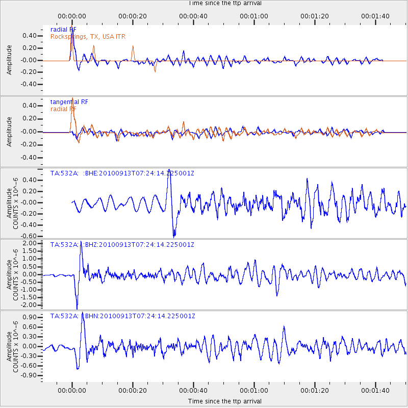
| Earthquake time(UTC): |
2010/09/13 (256) 07:15:49 GMT |
| Earthquake Depth: |
180 km |
| Earthquake Magnitude: |
5.6 MB, 5.9 MW, 5.8 MW |
| Earthquake Catalog/Contributor: |
WHDF/NEIC |
|
| Network: |
TA USArray Transportable Network (new EarthScope stations) |
| Station: |
532A Rocksprings, TX, USA |
| Lat/Lon: |
30.13 N/99.90 W |
| Elevation: |
703 m |
|
| Distance: |
52.6 deg |
| Az: |
327.935 deg |
| Baz: |
143.616 deg |
| Ray Param: |
0.06602225 |
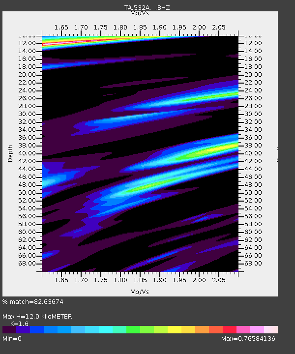
| Estimated Moho Depth: |
12.0 km |
| Estimated Crust Vp/Vs: |
1.60 |
| Assumed Crust Vp: |
6.498 km/s |
| Estimated Crust Vs: |
4.061 km/s |
| Estimated Crust Poisson's Ratio: |
0.18 |
|
| Radial Match: |
82.63674 % |
| Radial Bump: |
357 |
| Transverse Match: |
66.92355 % |
| Transverse Bump: |
398 |
| SOD ConfigId: |
319893 |
| Insert Time: |
2011-01-20 08:47:16.113 +0000 |
| GWidth: |
2.5 |
| Max Bumps: |
400 |
| Tol: |
0.001 |
|
Signal To Noise
| Channel | StoN | STA | LTA |
| TA:532A: :BHZ:20100913T07:24:14.225001Z | 16.53315 | 9.94452E-7 | 6.014897E-8 |
| TA:532A: :BHN:20100913T07:24:14.225001Z | 8.711545 | 4.9021077E-7 | 5.6271396E-8 |
| TA:532A: :BHE:20100913T07:24:14.225001Z | 4.5719643 | 3.5665488E-7 | 7.8009116E-8 |
| Arrivals |
| Ps | 1.2 SECOND |
| PpPs | 4.5 SECOND |
| PsPs/PpSs | 5.7 SECOND |


