You are here: Home > Network List > TA - USArray Transportable Network (new EarthScope stations) Stations List
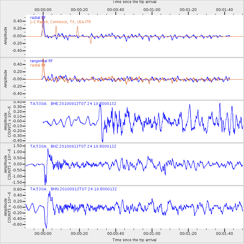
> Station 530A J-C Ranch, Comstock, TX, USA > Earthquake Result Viewer
530A J-C Ranch, Comstock, TX, USA - Earthquake Result Viewer
| Earthquake location: |
Central Peru |
| Earthquake latitude/longitude: |
-14.6/-70.8 |
| Earthquake time(UTC): |
2010/09/13 (256) 07:15:49 GMT |
| Earthquake Depth: |
180 km |
| Earthquake Magnitude: |
5.6 MB, 5.9 MW, 5.8 MW |
| Earthquake Catalog/Contributor: |
WHDF/NEIC |
|
| Network: |
TA USArray Transportable Network (new EarthScope stations) |
| Station: |
530A J-C Ranch, Comstock, TX, USA |
| Lat/Lon: |
30.15 N/101.34 W |
| Elevation: |
636 m |
|
| Distance: |
53.4 deg |
| Az: |
326.711 deg |
| Baz: |
142.163 deg |
| Ray Param: |
0.065528005 |
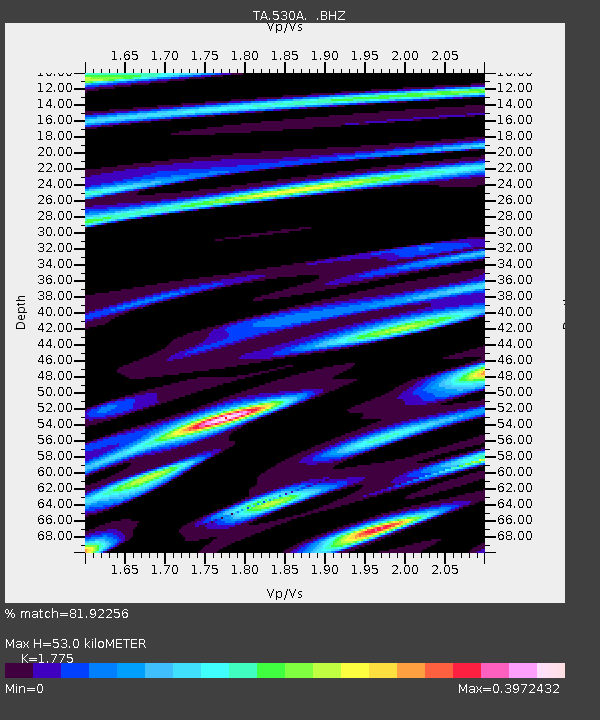
| Estimated Moho Depth: |
53.0 km |
| Estimated Crust Vp/Vs: |
1.77 |
| Assumed Crust Vp: |
6.38 km/s |
| Estimated Crust Vs: |
3.595 km/s |
| Estimated Crust Poisson's Ratio: |
0.27 |
|
| Radial Match: |
81.92256 % |
| Radial Bump: |
391 |
| Transverse Match: |
59.770752 % |
| Transverse Bump: |
400 |
| SOD ConfigId: |
319893 |
| Insert Time: |
2011-01-20 08:47:40.301 +0000 |
| GWidth: |
2.5 |
| Max Bumps: |
400 |
| Tol: |
0.001 |
|
Signal To Noise
| Channel | StoN | STA | LTA |
| TA:530A: :BHZ:20100913T07:24:19.800013Z | 11.191088 | 7.666105E-7 | 6.8501876E-8 |
| TA:530A: :BHN:20100913T07:24:19.800013Z | 4.2581778 | 3.6803627E-7 | 8.643046E-8 |
| TA:530A: :BHE:20100913T07:24:19.800013Z | 3.8754587 | 2.1091846E-7 | 5.4424127E-8 |
| Arrivals |
| Ps | 6.8 SECOND |
| PpPs | 22 SECOND |
| PsPs/PpSs | 29 SECOND |


