You are here: Home > Network List > UW - Pacific Northwest Regional Seismic Network Stations List
> Station HOOD Mt Hood Meadows, OR CREST BB SMO > Earthquake Result Viewer
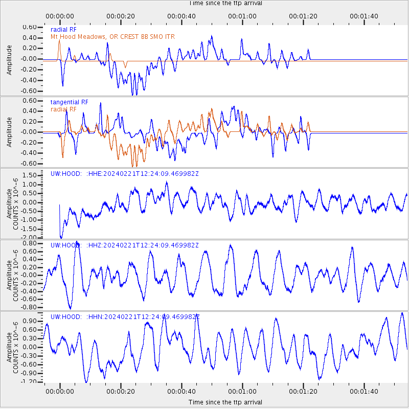
HOOD Mt Hood Meadows, OR CREST BB SMO - Earthquake Result Viewer
*The percent match for this event was below the threshold and hence no stack was calculated.
| Earthquake location: |
Admiralty Islands Region, P.N.G. |
| Earthquake latitude/longitude: |
-0.9/146.1 |
| Earthquake time(UTC): |
2024/02/21 (052) 12:11:31 GMT |
| Earthquake Depth: |
10 km |
| Earthquake Magnitude: |
5.5 Mww |
| Earthquake Catalog/Contributor: |
NEIC PDE/us |
|
| Network: |
UW Pacific Northwest Regional Seismic Network |
| Station: |
HOOD Mt Hood Meadows, OR CREST BB SMO |
| Lat/Lon: |
45.32 N/121.65 W |
| Elevation: |
1520 m |
|
| Distance: |
92.2 deg |
| Az: |
44.869 deg |
| Baz: |
270.976 deg |
| Ray Param: |
$rayparam |
*The percent match for this event was below the threshold and hence was not used in the summary stack. |
|
| Radial Match: |
29.799793 % |
| Radial Bump: |
400 |
| Transverse Match: |
46.343723 % |
| Transverse Bump: |
400 |
| SOD ConfigId: |
33437571 |
| Insert Time: |
2024-03-06 12:27:40.747 +0000 |
| GWidth: |
2.5 |
| Max Bumps: |
400 |
| Tol: |
0.001 |
|
Signal To Noise
| Channel | StoN | STA | LTA |
| UW:HOOD: :HHZ:20240221T12:24:09.469982Z | 1.7540009 | 4.6330564E-7 | 2.641422E-7 |
| UW:HOOD: :HHN:20240221T12:24:09.469982Z | 0.39738703 | 1.7843476E-7 | 4.490201E-7 |
| UW:HOOD: :HHE:20240221T12:24:09.469982Z | 1.678604 | 9.342261E-7 | 5.565494E-7 |
| Arrivals |
| Ps | |
| PpPs | |
| PsPs/PpSs | |


