You are here: Home > Network List > TA - USArray Transportable Network (new EarthScope stations) Stations List
> Station S30A Montezuma, KS, USA > Earthquake Result Viewer
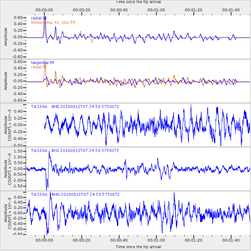
S30A Montezuma, KS, USA - Earthquake Result Viewer
*The percent match for this event was below the threshold and hence no stack was calculated.
| Earthquake location: |
Central Peru |
| Earthquake latitude/longitude: |
-14.6/-70.8 |
| Earthquake time(UTC): |
2010/09/13 (256) 07:15:49 GMT |
| Earthquake Depth: |
180 km |
| Earthquake Magnitude: |
5.6 MB, 5.9 MW, 5.8 MW |
| Earthquake Catalog/Contributor: |
WHDF/NEIC |
|
| Network: |
TA USArray Transportable Network (new EarthScope stations) |
| Station: |
S30A Montezuma, KS, USA |
| Lat/Lon: |
37.64 N/100.46 W |
| Elevation: |
853 m |
|
| Distance: |
59.0 deg |
| Az: |
332.696 deg |
| Baz: |
145.986 deg |
| Ray Param: |
$rayparam |
*The percent match for this event was below the threshold and hence was not used in the summary stack. |
|
| Radial Match: |
73.4181 % |
| Radial Bump: |
379 |
| Transverse Match: |
55.525944 % |
| Transverse Bump: |
400 |
| SOD ConfigId: |
319893 |
| Insert Time: |
2011-01-20 08:50:09.636 +0000 |
| GWidth: |
2.5 |
| Max Bumps: |
400 |
| Tol: |
0.001 |
|
Signal To Noise
| Channel | StoN | STA | LTA |
| TA:S30A: :BHZ:20100913T07:24:59.575007Z | 8.602764 | 8.0409615E-7 | 9.346951E-8 |
| TA:S30A: :BHN:20100913T07:24:59.575007Z | 2.5480118 | 4.044961E-7 | 1.587497E-7 |
| TA:S30A: :BHE:20100913T07:24:59.575007Z | 1.4519565 | 2.3743058E-7 | 1.6352459E-7 |
| Arrivals |
| Ps | |
| PpPs | |
| PsPs/PpSs | |


