You are here: Home > Network List > ZJ12 - Transantarctic Mountains Northern Network Stations List
> Station SHRD Lister Nunataks, Antarctica > Earthquake Result Viewer
SHRD Lister Nunataks, Antarctica - Earthquake Result Viewer
| Earthquake location: |
Vanuatu Islands |
| Earthquake latitude/longitude: |
-13.9/167.2 |
| Earthquake time(UTC): |
2014/01/01 (001) 16:03:29 GMT |
| Earthquake Depth: |
187 km |
| Earthquake Magnitude: |
6.5 MWW, 6.5 MWC, 6.6 MWC, 6.6 MI, 6.6 MWB |
| Earthquake Catalog/Contributor: |
NEIC PDE/NEIC COMCAT |
|
| Network: |
ZJ Transantarctic Mountains Northern Network |
| Station: |
SHRD Lister Nunataks, Antarctica |
| Lat/Lon: |
73.40 S/160.50 E |
| Elevation: |
2457 m |
|
| Distance: |
59.6 deg |
| Az: |
182.244 deg |
| Baz: |
7.602 deg |
| Ray Param: |
0.061453205 |
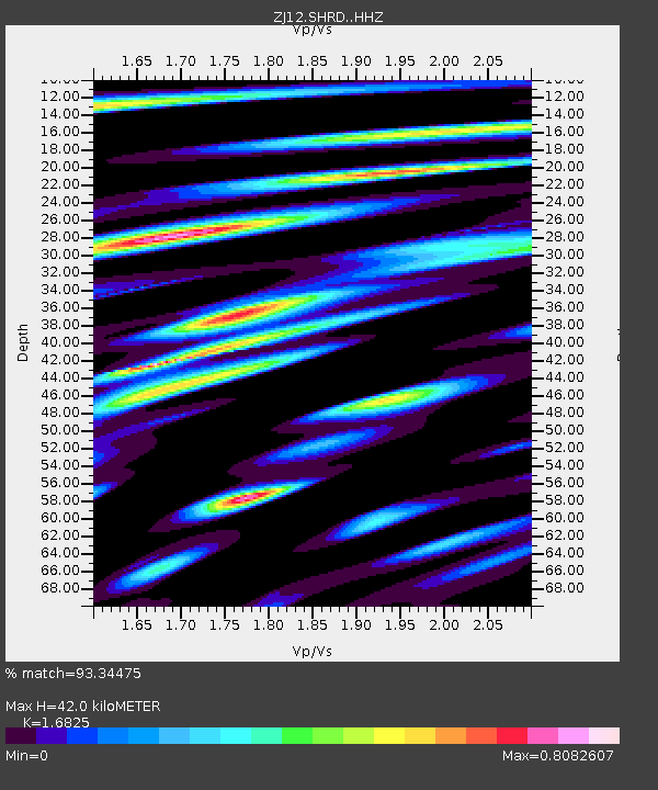
| Estimated Moho Depth: |
42.0 km |
| Estimated Crust Vp/Vs: |
1.68 |
| Assumed Crust Vp: |
6.264 km/s |
| Estimated Crust Vs: |
3.723 km/s |
| Estimated Crust Poisson's Ratio: |
0.23 |
|
| Radial Match: |
93.34475 % |
| Radial Bump: |
400 |
| Transverse Match: |
85.7828 % |
| Transverse Bump: |
400 |
| SOD ConfigId: |
3382691 |
| Insert Time: |
2019-04-09 20:32:46.413 +0000 |
| GWidth: |
2.5 |
| Max Bumps: |
400 |
| Tol: |
0.001 |
|

Signal To Noise
| Channel | StoN | STA | LTA |
| ZJ:SHRD: :HHZ:20140101T16:12:42.499023Z | 76.80011 | 7.6712795E-6 | 9.988631E-8 |
| ZJ:SHRD: :HHN:20140101T16:12:42.499023Z | 49.433475 | 4.3063415E-6 | 8.7113875E-8 |
| ZJ:SHRD: :HHE:20140101T16:12:42.499023Z | 8.904672 | 7.704624E-7 | 8.652339E-8 |
| Arrivals |
| Ps | 4.8 SECOND |
| PpPs | 17 SECOND |
| PsPs/PpSs | 22 SECOND |


