You are here: Home > Network List > GT - Global Telemetered Seismograph Network (USAF/USGS) Stations List
> Station LPAZ La Paz , Bolivia > Earthquake Result Viewer
LPAZ La Paz , Bolivia - Earthquake Result Viewer
| Earthquake location: |
Southern East Pacific Rise |
| Earthquake latitude/longitude: |
-35.1/-110.8 |
| Earthquake time(UTC): |
2024/02/23 (054) 01:51:12 GMT |
| Earthquake Depth: |
2.0 km |
| Earthquake Magnitude: |
6.3 Mww |
| Earthquake Catalog/Contributor: |
NEIC PDE/us |
|
| Network: |
GT Global Telemetered Seismograph Network (USAF/USGS) |
| Station: |
LPAZ La Paz , Bolivia |
| Lat/Lon: |
16.17 S/68.08 W |
| Elevation: |
4817 m |
|
| Distance: |
42.5 deg |
| Az: |
74.764 deg |
| Baz: |
235.394 deg |
| Ray Param: |
0.07316984 |
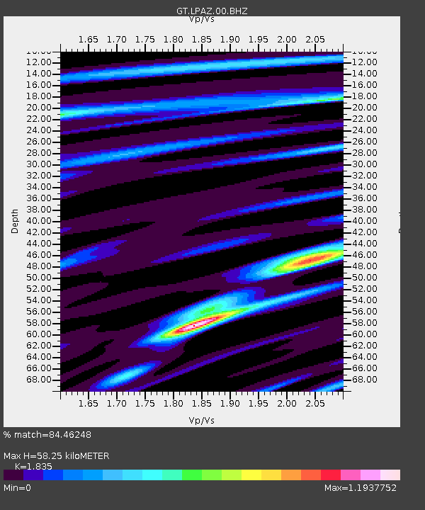
| Estimated Moho Depth: |
58.25 km |
| Estimated Crust Vp/Vs: |
1.84 |
| Assumed Crust Vp: |
6.454 km/s |
| Estimated Crust Vs: |
3.517 km/s |
| Estimated Crust Poisson's Ratio: |
0.29 |
|
| Radial Match: |
84.46248 % |
| Radial Bump: |
400 |
| Transverse Match: |
83.75879 % |
| Transverse Bump: |
400 |
| SOD ConfigId: |
33437571 |
| Insert Time: |
2024-03-08 02:01:58.926 +0000 |
| GWidth: |
2.5 |
| Max Bumps: |
400 |
| Tol: |
0.001 |
|
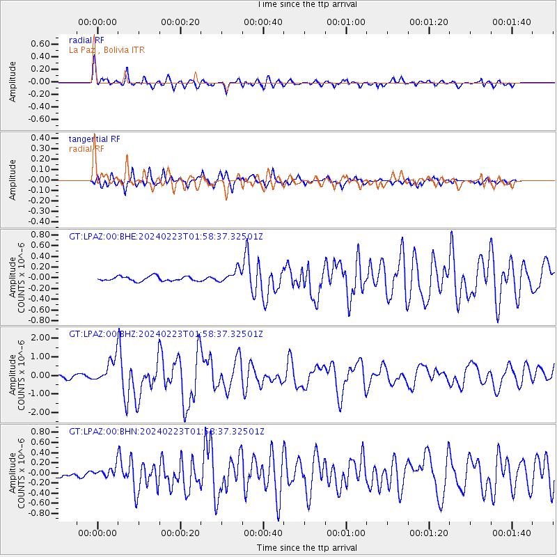
Signal To Noise
| Channel | StoN | STA | LTA |
| GT:LPAZ:00:BHZ:20240223T01:58:37.32501Z | 9.358936 | 7.409245E-7 | 7.916759E-8 |
| GT:LPAZ:00:BHN:20240223T01:58:37.32501Z | 1.9031428 | 1.2549845E-7 | 6.5942736E-8 |
| GT:LPAZ:00:BHE:20240223T01:58:37.32501Z | 4.2836437 | 1.8519926E-7 | 4.3234046E-8 |
| Arrivals |
| Ps | 8.0 SECOND |
| PpPs | 24 SECOND |
| PsPs/PpSs | 32 SECOND |


