You are here: Home > Network List > TA - USArray Transportable Network (new EarthScope stations) Stations List
> Station Q31A Ellis, KS, USA > Earthquake Result Viewer
Q31A Ellis, KS, USA - Earthquake Result Viewer
| Earthquake location: |
Central Peru |
| Earthquake latitude/longitude: |
-14.6/-70.8 |
| Earthquake time(UTC): |
2010/09/13 (256) 07:15:49 GMT |
| Earthquake Depth: |
180 km |
| Earthquake Magnitude: |
5.6 MB, 5.9 MW, 5.8 MW |
| Earthquake Catalog/Contributor: |
WHDF/NEIC |
|
| Network: |
TA USArray Transportable Network (new EarthScope stations) |
| Station: |
Q31A Ellis, KS, USA |
| Lat/Lon: |
39.00 N/99.39 W |
| Elevation: |
680 m |
|
| Distance: |
59.7 deg |
| Az: |
334.382 deg |
| Baz: |
147.507 deg |
| Ray Param: |
0.061465584 |
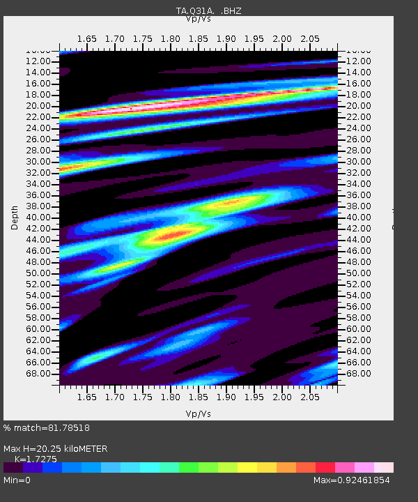
| Estimated Moho Depth: |
20.25 km |
| Estimated Crust Vp/Vs: |
1.73 |
| Assumed Crust Vp: |
6.483 km/s |
| Estimated Crust Vs: |
3.753 km/s |
| Estimated Crust Poisson's Ratio: |
0.25 |
|
| Radial Match: |
81.78518 % |
| Radial Bump: |
400 |
| Transverse Match: |
66.559166 % |
| Transverse Bump: |
400 |
| SOD ConfigId: |
319893 |
| Insert Time: |
2011-01-20 08:51:24.690 +0000 |
| GWidth: |
2.5 |
| Max Bumps: |
400 |
| Tol: |
0.001 |
|

Signal To Noise
| Channel | StoN | STA | LTA |
| TA:Q31A: :BHZ:20100913T07:25:04.200007Z | 7.6256304 | 1.037175E-6 | 1.3601172E-7 |
| TA:Q31A: :BHN:20100913T07:25:04.200007Z | 4.8661127 | 6.044482E-7 | 1.2421582E-7 |
| TA:Q31A: :BHE:20100913T07:25:04.200007Z | 2.9407742 | 5.278501E-7 | 1.7949358E-7 |
| Arrivals |
| Ps | 2.4 SECOND |
| PpPs | 8.1 SECOND |
| PsPs/PpSs | 11 SECOND |


