You are here: Home > Network List > TA - USArray Transportable Network (new EarthScope stations) Stations List
> Station P31A Stockton, KS, USA > Earthquake Result Viewer
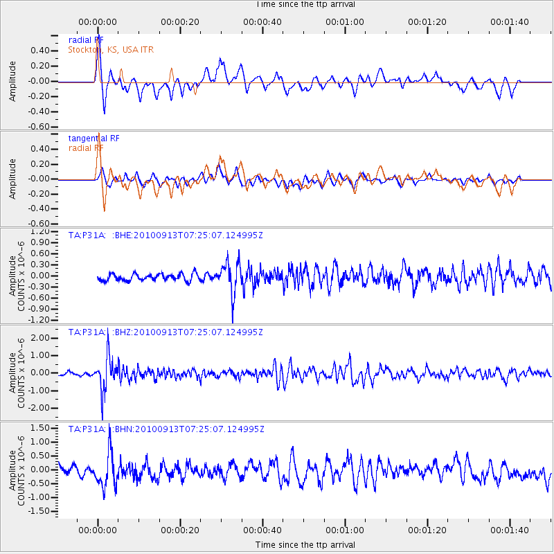
P31A Stockton, KS, USA - Earthquake Result Viewer
*The percent match for this event was below the threshold and hence no stack was calculated.
| Earthquake location: |
Central Peru |
| Earthquake latitude/longitude: |
-14.6/-70.8 |
| Earthquake time(UTC): |
2010/09/13 (256) 07:15:49 GMT |
| Earthquake Depth: |
180 km |
| Earthquake Magnitude: |
5.6 MB, 5.9 MW, 5.8 MW |
| Earthquake Catalog/Contributor: |
WHDF/NEIC |
|
| Network: |
TA USArray Transportable Network (new EarthScope stations) |
| Station: |
P31A Stockton, KS, USA |
| Lat/Lon: |
39.52 N/99.38 W |
| Elevation: |
665 m |
|
| Distance: |
60.1 deg |
| Az: |
334.714 deg |
| Baz: |
147.684 deg |
| Ray Param: |
$rayparam |
*The percent match for this event was below the threshold and hence was not used in the summary stack. |
|
| Radial Match: |
74.85422 % |
| Radial Bump: |
400 |
| Transverse Match: |
57.1051 % |
| Transverse Bump: |
400 |
| SOD ConfigId: |
319893 |
| Insert Time: |
2011-01-20 08:51:37.388 +0000 |
| GWidth: |
2.5 |
| Max Bumps: |
400 |
| Tol: |
0.001 |
|
Signal To Noise
| Channel | StoN | STA | LTA |
| TA:P31A: :BHZ:20100913T07:25:07.124995Z | 13.379295 | 9.58651E-7 | 7.1651826E-8 |
| TA:P31A: :BHN:20100913T07:25:07.124995Z | 3.9656389 | 6.354067E-7 | 1.6022808E-7 |
| TA:P31A: :BHE:20100913T07:25:07.124995Z | 4.574304 | 4.2076522E-7 | 9.1984525E-8 |
| Arrivals |
| Ps | |
| PpPs | |
| PsPs/PpSs | |


