You are here: Home > Network List > PR - Puerto Rico Seismic Network (PRSN) & Puerto Rico Strong Motion Program (PRSMP) Stations List
> Station MLPR Magueyes > Earthquake Result Viewer
MLPR Magueyes - Earthquake Result Viewer
| Earthquake location: |
Southern East Pacific Rise |
| Earthquake latitude/longitude: |
-35.1/-110.8 |
| Earthquake time(UTC): |
2024/02/23 (054) 01:51:12 GMT |
| Earthquake Depth: |
2.0 km |
| Earthquake Magnitude: |
6.3 Mww |
| Earthquake Catalog/Contributor: |
NEIC PDE/us |
|
| Network: |
PR Puerto Rico Seismic Network (PRSN) & Puerto Rico Strong Motion Program (PRSMP) |
| Station: |
MLPR Magueyes |
| Lat/Lon: |
17.97 N/67.04 W |
| Elevation: |
0.0 m |
|
| Distance: |
67.2 deg |
| Az: |
45.566 deg |
| Baz: |
217.949 deg |
| Ray Param: |
0.057149578 |
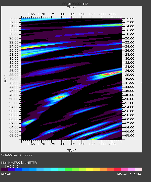
| Estimated Moho Depth: |
37.0 km |
| Estimated Crust Vp/Vs: |
2.05 |
| Assumed Crust Vp: |
4.082 km/s |
| Estimated Crust Vs: |
1.996 km/s |
| Estimated Crust Poisson's Ratio: |
0.34 |
|
| Radial Match: |
84.02922 % |
| Radial Bump: |
400 |
| Transverse Match: |
74.862144 % |
| Transverse Bump: |
400 |
| SOD ConfigId: |
33437571 |
| Insert Time: |
2024-03-08 02:10:21.075 +0000 |
| GWidth: |
2.5 |
| Max Bumps: |
400 |
| Tol: |
0.001 |
|

Signal To Noise
| Channel | StoN | STA | LTA |
| PR:MLPR:00:HHZ:20240223T02:01:36.600003Z | 3.1815374 | 8.8573876E-7 | 2.783996E-7 |
| PR:MLPR:00:HH1:20240223T02:01:36.600003Z | 2.0339797 | 3.8365746E-7 | 1.8862404E-7 |
| PR:MLPR:00:HH2:20240223T02:01:36.600003Z | 2.176372 | 5.159534E-7 | 2.370704E-7 |
| Arrivals |
| Ps | 9.6 SECOND |
| PpPs | 27 SECOND |
| PsPs/PpSs | 37 SECOND |


