You are here: Home > Network List > TA - USArray Transportable Network (new EarthScope stations) Stations List
> Station A30A Hoffart Farm, Langdon, ND, USA > Earthquake Result Viewer
A30A Hoffart Farm, Langdon, ND, USA - Earthquake Result Viewer

| Earthquake location: |
Central Peru |
| Earthquake latitude/longitude: |
-14.6/-70.8 |
| Earthquake time(UTC): |
2010/09/13 (256) 07:15:49 GMT |
| Earthquake Depth: |
180 km |
| Earthquake Magnitude: |
5.6 MB, 5.9 MW, 5.8 MW |
| Earthquake Catalog/Contributor: |
WHDF/NEIC |
|
| Network: |
TA USArray Transportable Network (new EarthScope stations) |
| Station: |
A30A Hoffart Farm, Langdon, ND, USA |
| Lat/Lon: |
48.94 N/98.30 W |
| Elevation: |
484 m |
|
| Distance: |
67.8 deg |
| Az: |
340.788 deg |
| Baz: |
151.11 deg |
| Ray Param: |
0.056203626 |
| Estimated Moho Depth: |
30.75 km |
| Estimated Crust Vp/Vs: |
1.60 |
| Assumed Crust Vp: |
6.53 km/s |
| Estimated Crust Vs: |
4.082 km/s |
| Estimated Crust Poisson's Ratio: |
0.18 |
|
| Radial Match: |
83.164734 % |
| Radial Bump: |
400 |
| Transverse Match: |
75.30907 % |
| Transverse Bump: |
400 |
| SOD ConfigId: |
319893 |
| Insert Time: |
2011-01-20 08:55:25.023 +0000 |
| GWidth: |
2.5 |
| Max Bumps: |
400 |
| Tol: |
0.001 |
|
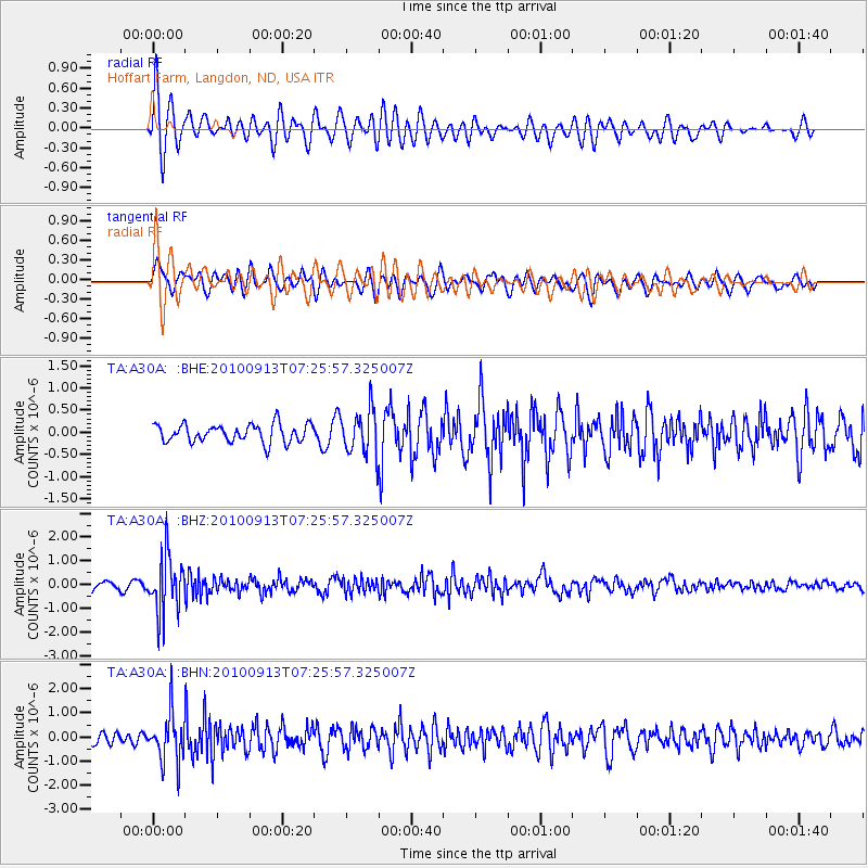
Signal To Noise
| Channel | StoN | STA | LTA |
| TA:A30A: :BHZ:20100913T07:25:57.325007Z | 6.90808 | 1.1877073E-6 | 1.7193015E-7 |
| TA:A30A: :BHN:20100913T07:25:57.325007Z | 4.483883 | 1.0222898E-6 | 2.2799207E-7 |
| TA:A30A: :BHE:20100913T07:25:57.325007Z | 2.4840891 | 5.011848E-7 | 2.0175796E-7 |
| Arrivals |
| Ps | 3.0 SECOND |
| PpPs | 12 SECOND |
| PsPs/PpSs | 15 SECOND |


