You are here: Home > Network List > UW - Pacific Northwest Regional Seismic Network Stations List
> Station FMW Mt. Fremont, WA, USA > Earthquake Result Viewer
FMW Mt. Fremont, WA, USA - Earthquake Result Viewer
| Earthquake location: |
Southern East Pacific Rise |
| Earthquake latitude/longitude: |
-35.1/-110.8 |
| Earthquake time(UTC): |
2024/02/23 (054) 01:51:12 GMT |
| Earthquake Depth: |
2.0 km |
| Earthquake Magnitude: |
6.3 Mww |
| Earthquake Catalog/Contributor: |
NEIC PDE/us |
|
| Network: |
UW Pacific Northwest Regional Seismic Network |
| Station: |
FMW Mt. Fremont, WA, USA |
| Lat/Lon: |
46.94 N/121.67 W |
| Elevation: |
1900 m |
|
| Distance: |
82.3 deg |
| Az: |
352.497 deg |
| Baz: |
171.012 deg |
| Ray Param: |
0.047016483 |
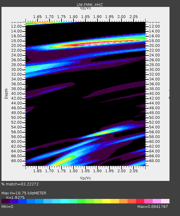
| Estimated Moho Depth: |
18.75 km |
| Estimated Crust Vp/Vs: |
1.93 |
| Assumed Crust Vp: |
6.597 km/s |
| Estimated Crust Vs: |
3.423 km/s |
| Estimated Crust Poisson's Ratio: |
0.32 |
|
| Radial Match: |
83.22272 % |
| Radial Bump: |
400 |
| Transverse Match: |
72.379 % |
| Transverse Bump: |
400 |
| SOD ConfigId: |
33437571 |
| Insert Time: |
2024-03-08 02:17:19.039 +0000 |
| GWidth: |
2.5 |
| Max Bumps: |
400 |
| Tol: |
0.001 |
|

Signal To Noise
| Channel | StoN | STA | LTA |
| UW:FMW: :HHZ:20240223T02:03:03.920011Z | 1.2401565 | 2.5180523E-7 | 2.030431E-7 |
| UW:FMW: :HHN:20240223T02:03:03.920011Z | 1.1742214 | 2.7268663E-7 | 2.3222762E-7 |
| UW:FMW: :HHE:20240223T02:03:03.920011Z | 0.44504228 | 9.620193E-8 | 2.1616357E-7 |
| Arrivals |
| Ps | 2.7 SECOND |
| PpPs | 8.1 SECOND |
| PsPs/PpSs | 11 SECOND |


