You are here: Home > Network List > TA - USArray Transportable Network (new EarthScope stations) Stations List
> Station H29A Onida, SD, USA > Earthquake Result Viewer
H29A Onida, SD, USA - Earthquake Result Viewer
| Earthquake location: |
Central Peru |
| Earthquake latitude/longitude: |
-14.6/-70.8 |
| Earthquake time(UTC): |
2010/09/13 (256) 07:15:49 GMT |
| Earthquake Depth: |
180 km |
| Earthquake Magnitude: |
5.6 MB, 5.9 MW, 5.8 MW |
| Earthquake Catalog/Contributor: |
WHDF/NEIC |
|
| Network: |
TA USArray Transportable Network (new EarthScope stations) |
| Station: |
H29A Onida, SD, USA |
| Lat/Lon: |
44.63 N/100.21 W |
| Elevation: |
548 m |
|
| Distance: |
64.8 deg |
| Az: |
337.171 deg |
| Baz: |
148.265 deg |
| Ray Param: |
0.05818991 |
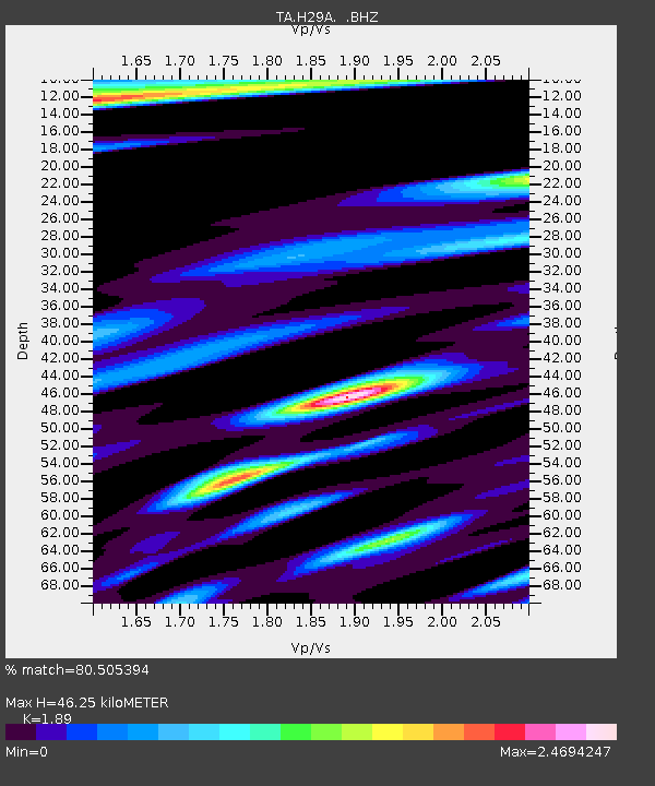
| Estimated Moho Depth: |
46.25 km |
| Estimated Crust Vp/Vs: |
1.89 |
| Assumed Crust Vp: |
6.53 km/s |
| Estimated Crust Vs: |
3.455 km/s |
| Estimated Crust Poisson's Ratio: |
0.31 |
|
| Radial Match: |
80.505394 % |
| Radial Bump: |
400 |
| Transverse Match: |
70.18574 % |
| Transverse Bump: |
400 |
| SOD ConfigId: |
319893 |
| Insert Time: |
2011-01-20 08:56:37.695 +0000 |
| GWidth: |
2.5 |
| Max Bumps: |
400 |
| Tol: |
0.001 |
|

Signal To Noise
| Channel | StoN | STA | LTA |
| TA:H29A: :BHZ:20100913T07:25:37.924983Z | 12.893569 | 1.1591053E-6 | 8.9897945E-8 |
| TA:H29A: :BHN:20100913T07:25:37.924983Z | 3.077093 | 9.701741E-7 | 3.1528918E-7 |
| TA:H29A: :BHE:20100913T07:25:37.924983Z | 2.039062 | 5.4243316E-7 | 2.6602092E-7 |
| Arrivals |
| Ps | 6.6 SECOND |
| PpPs | 20 SECOND |
| PsPs/PpSs | 26 SECOND |


