You are here: Home > Network List > TA - USArray Transportable Network (new EarthScope stations) Stations List
> Station R32A Long Quarter, Great Bend, KS, USA > Earthquake Result Viewer
R32A Long Quarter, Great Bend, KS, USA - Earthquake Result Viewer
| Earthquake location: |
Central Peru |
| Earthquake latitude/longitude: |
-14.6/-70.8 |
| Earthquake time(UTC): |
2010/09/13 (256) 07:15:49 GMT |
| Earthquake Depth: |
180 km |
| Earthquake Magnitude: |
5.6 MB, 5.9 MW, 5.8 MW |
| Earthquake Catalog/Contributor: |
WHDF/NEIC |
|
| Network: |
TA USArray Transportable Network (new EarthScope stations) |
| Station: |
R32A Long Quarter, Great Bend, KS, USA |
| Lat/Lon: |
38.42 N/98.71 W |
| Elevation: |
573 m |
|
| Distance: |
58.9 deg |
| Az: |
334.548 deg |
| Baz: |
148.017 deg |
| Ray Param: |
0.061969288 |
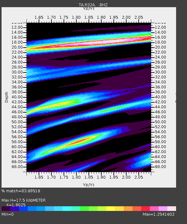
| Estimated Moho Depth: |
17.5 km |
| Estimated Crust Vp/Vs: |
1.90 |
| Assumed Crust Vp: |
6.483 km/s |
| Estimated Crust Vs: |
3.407 km/s |
| Estimated Crust Poisson's Ratio: |
0.31 |
|
| Radial Match: |
83.69516 % |
| Radial Bump: |
400 |
| Transverse Match: |
71.73357 % |
| Transverse Bump: |
400 |
| SOD ConfigId: |
319893 |
| Insert Time: |
2011-01-20 08:59:33.424 +0000 |
| GWidth: |
2.5 |
| Max Bumps: |
400 |
| Tol: |
0.001 |
|

Signal To Noise
| Channel | StoN | STA | LTA |
| TA:R32A: :BHZ:20100913T07:24:58.90002Z | 9.972671 | 1.0576925E-6 | 1.060591E-7 |
| TA:R32A: :BHN:20100913T07:24:58.90002Z | 5.2564173 | 5.293691E-7 | 1.0070911E-7 |
| TA:R32A: :BHE:20100913T07:24:58.90002Z | 3.6698265 | 4.39926E-7 | 1.198765E-7 |
| Arrivals |
| Ps | 2.5 SECOND |
| PpPs | 7.5 SECOND |
| PsPs/PpSs | 10 SECOND |


