You are here: Home > Network List > TA - USArray Transportable Network (new EarthScope stations) Stations List
> Station 333A Richland Springs, TX, USA > Earthquake Result Viewer
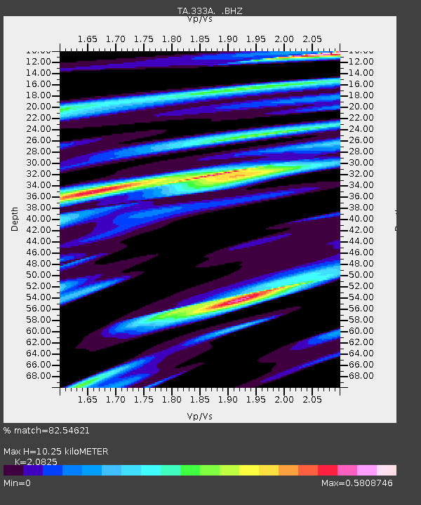
333A Richland Springs, TX, USA - Earthquake Result Viewer
| Earthquake location: |
Central Peru |
| Earthquake latitude/longitude: |
-14.6/-70.8 |
| Earthquake time(UTC): |
2010/09/13 (256) 07:15:49 GMT |
| Earthquake Depth: |
180 km |
| Earthquake Magnitude: |
5.6 MB, 5.9 MW, 5.8 MW |
| Earthquake Catalog/Contributor: |
WHDF/NEIC |
|
| Network: |
TA USArray Transportable Network (new EarthScope stations) |
| Station: |
333A Richland Springs, TX, USA |
| Lat/Lon: |
31.32 N/98.98 W |
| Elevation: |
443 m |
|
| Distance: |
53.1 deg |
| Az: |
329.616 deg |
| Baz: |
145.099 deg |
| Ray Param: |
0.06568716 |
| Estimated Moho Depth: |
10.25 km |
| Estimated Crust Vp/Vs: |
2.08 |
| Assumed Crust Vp: |
6.498 km/s |
| Estimated Crust Vs: |
3.12 km/s |
| Estimated Crust Poisson's Ratio: |
0.35 |
|
| Radial Match: |
82.54621 % |
| Radial Bump: |
394 |
| Transverse Match: |
66.79238 % |
| Transverse Bump: |
400 |
| SOD ConfigId: |
319893 |
| Insert Time: |
2011-01-20 09:01:10.145 +0000 |
| GWidth: |
2.5 |
| Max Bumps: |
400 |
| Tol: |
0.001 |
|

Signal To Noise
| Channel | StoN | STA | LTA |
| TA:333A: :BHZ:20100913T07:24:17.925013Z | 8.359407 | 6.7590213E-7 | 8.085527E-8 |
| TA:333A: :BHN:20100913T07:24:17.925013Z | 6.688787 | 2.9524261E-7 | 4.413993E-8 |
| TA:333A: :BHE:20100913T07:24:17.925013Z | 3.5243514 | 1.9708497E-7 | 5.592092E-8 |
| Arrivals |
| Ps | 1.8 SECOND |
| PpPs | 4.6 SECOND |
| PsPs/PpSs | 6.4 SECOND |


