You are here: Home > Network List > TA - USArray Transportable Network (new EarthScope stations) Stations List
> Station 334A Lometa, TX, USA > Earthquake Result Viewer
334A Lometa, TX, USA - Earthquake Result Viewer
| Earthquake location: |
Central Peru |
| Earthquake latitude/longitude: |
-14.6/-70.8 |
| Earthquake time(UTC): |
2010/09/13 (256) 07:15:49 GMT |
| Earthquake Depth: |
180 km |
| Earthquake Magnitude: |
5.6 MB, 5.9 MW, 5.8 MW |
| Earthquake Catalog/Contributor: |
WHDF/NEIC |
|
| Network: |
TA USArray Transportable Network (new EarthScope stations) |
| Station: |
334A Lometa, TX, USA |
| Lat/Lon: |
31.33 N/98.24 W |
| Elevation: |
389 m |
|
| Distance: |
52.7 deg |
| Az: |
330.281 deg |
| Baz: |
145.886 deg |
| Ray Param: |
0.06592159 |
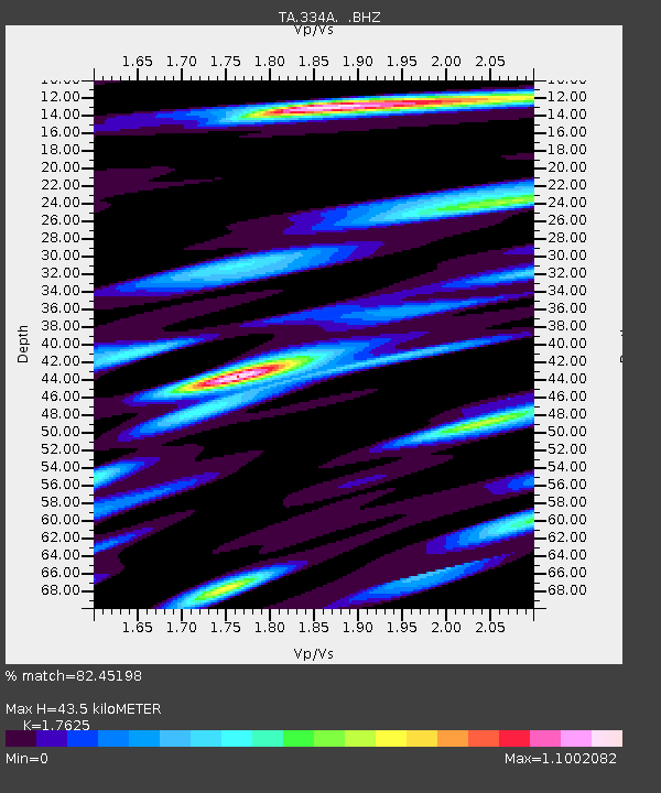
| Estimated Moho Depth: |
43.5 km |
| Estimated Crust Vp/Vs: |
1.76 |
| Assumed Crust Vp: |
6.498 km/s |
| Estimated Crust Vs: |
3.687 km/s |
| Estimated Crust Poisson's Ratio: |
0.26 |
|
| Radial Match: |
82.45198 % |
| Radial Bump: |
400 |
| Transverse Match: |
67.4457 % |
| Transverse Bump: |
360 |
| SOD ConfigId: |
319893 |
| Insert Time: |
2011-01-20 09:01:12.557 +0000 |
| GWidth: |
2.5 |
| Max Bumps: |
400 |
| Tol: |
0.001 |
|
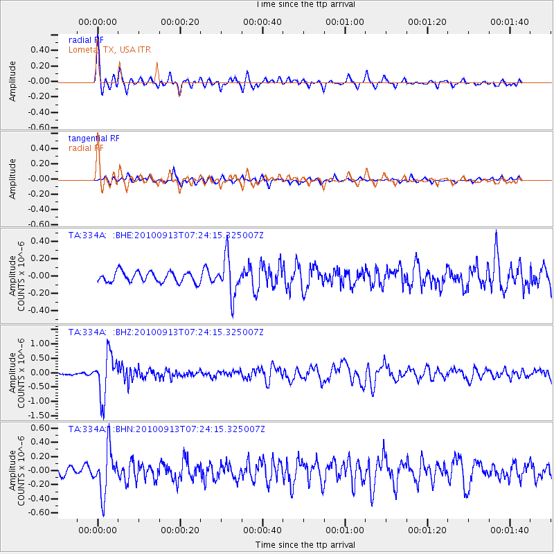
Signal To Noise
| Channel | StoN | STA | LTA |
| TA:334A: :BHZ:20100913T07:24:15.325007Z | 7.631251 | 7.5496365E-7 | 9.893052E-8 |
| TA:334A: :BHN:20100913T07:24:15.325007Z | 5.941163 | 3.2284765E-7 | 5.4340813E-8 |
| TA:334A: :BHE:20100913T07:24:15.325007Z | 3.8412037 | 2.2889942E-7 | 5.9590544E-8 |
| Arrivals |
| Ps | 5.4 SECOND |
| PpPs | 17 SECOND |
| PsPs/PpSs | 23 SECOND |


