You are here: Home > Network List > TA - USArray Transportable Network (new EarthScope stations) Stations List
> Station 134A White-Moore Ranch, Lipan, TX, USA > Earthquake Result Viewer
134A White-Moore Ranch, Lipan, TX, USA - Earthquake Result Viewer
| Earthquake location: |
Central Peru |
| Earthquake latitude/longitude: |
-14.6/-70.8 |
| Earthquake time(UTC): |
2010/09/13 (256) 07:15:49 GMT |
| Earthquake Depth: |
180 km |
| Earthquake Magnitude: |
5.6 MB, 5.9 MW, 5.8 MW |
| Earthquake Catalog/Contributor: |
WHDF/NEIC |
|
| Network: |
TA USArray Transportable Network (new EarthScope stations) |
| Station: |
134A White-Moore Ranch, Lipan, TX, USA |
| Lat/Lon: |
32.57 N/98.08 W |
| Elevation: |
297 m |
|
| Distance: |
53.7 deg |
| Az: |
331.279 deg |
| Baz: |
146.567 deg |
| Ray Param: |
0.06531866 |
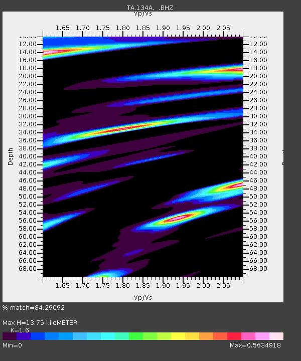
| Estimated Moho Depth: |
13.75 km |
| Estimated Crust Vp/Vs: |
1.60 |
| Assumed Crust Vp: |
6.426 km/s |
| Estimated Crust Vs: |
4.016 km/s |
| Estimated Crust Poisson's Ratio: |
0.18 |
|
| Radial Match: |
84.29092 % |
| Radial Bump: |
388 |
| Transverse Match: |
71.06585 % |
| Transverse Bump: |
400 |
| SOD ConfigId: |
319893 |
| Insert Time: |
2011-01-20 09:01:24.636 +0000 |
| GWidth: |
2.5 |
| Max Bumps: |
400 |
| Tol: |
0.001 |
|

Signal To Noise
| Channel | StoN | STA | LTA |
| TA:134A: :BHZ:20100913T07:24:22.27502Z | 12.421987 | 1.1425097E-6 | 9.19748E-8 |
| TA:134A: :BHN:20100913T07:24:22.27502Z | 6.987324 | 5.8668655E-7 | 8.396441E-8 |
| TA:134A: :BHE:20100913T07:24:22.27502Z | 4.5681705 | 4.410628E-7 | 9.6551304E-8 |
| Arrivals |
| Ps | 1.4 SECOND |
| PpPs | 5.2 SECOND |
| PsPs/PpSs | 6.6 SECOND |


