You are here: Home > Network List > TA - USArray Transportable Network (new EarthScope stations) Stations List
> Station 633A Saathoff Ranch, Hondo, TX, USA > Earthquake Result Viewer
633A Saathoff Ranch, Hondo, TX, USA - Earthquake Result Viewer
| Earthquake location: |
Central Peru |
| Earthquake latitude/longitude: |
-14.6/-70.8 |
| Earthquake time(UTC): |
2010/09/13 (256) 07:15:49 GMT |
| Earthquake Depth: |
180 km |
| Earthquake Magnitude: |
5.6 MB, 5.9 MW, 5.8 MW |
| Earthquake Catalog/Contributor: |
WHDF/NEIC |
|
| Network: |
TA USArray Transportable Network (new EarthScope stations) |
| Station: |
633A Saathoff Ranch, Hondo, TX, USA |
| Lat/Lon: |
29.46 N/99.18 W |
| Elevation: |
320 m |
|
| Distance: |
51.7 deg |
| Az: |
328.085 deg |
| Baz: |
144.067 deg |
| Ray Param: |
0.066620916 |
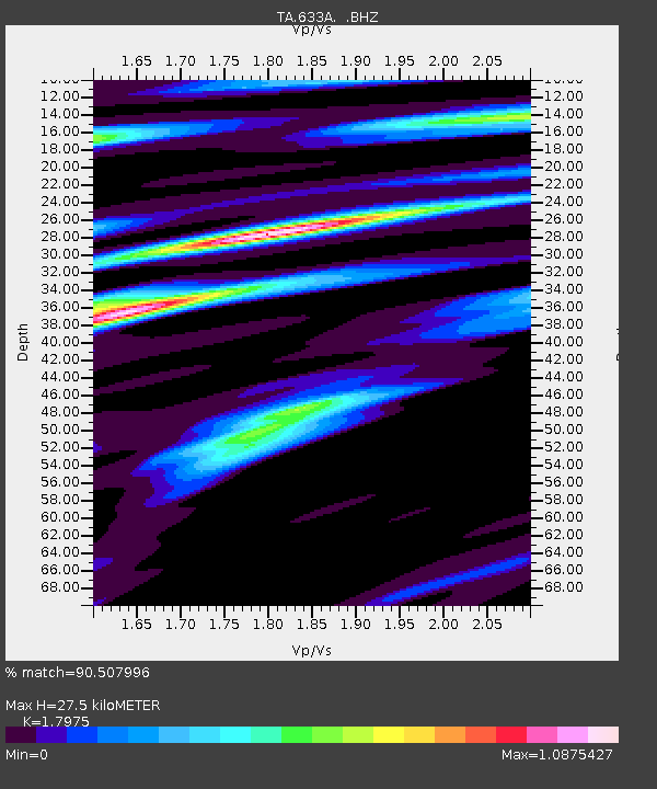
| Estimated Moho Depth: |
27.5 km |
| Estimated Crust Vp/Vs: |
1.80 |
| Assumed Crust Vp: |
6.347 km/s |
| Estimated Crust Vs: |
3.531 km/s |
| Estimated Crust Poisson's Ratio: |
0.28 |
|
| Radial Match: |
90.507996 % |
| Radial Bump: |
342 |
| Transverse Match: |
80.09101 % |
| Transverse Bump: |
400 |
| SOD ConfigId: |
319893 |
| Insert Time: |
2011-01-20 09:01:59.834 +0000 |
| GWidth: |
2.5 |
| Max Bumps: |
400 |
| Tol: |
0.001 |
|
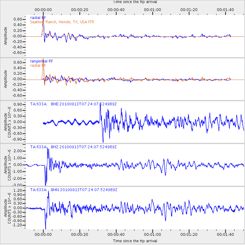
Signal To Noise
| Channel | StoN | STA | LTA |
| TA:633A: :BHZ:20100913T07:24:07.524989Z | 18.220896 | 1.2623158E-6 | 6.927847E-8 |
| TA:633A: :BHN:20100913T07:24:07.524989Z | 10.42723 | 5.279482E-7 | 5.0631684E-8 |
| TA:633A: :BHE:20100913T07:24:07.524989Z | 5.9725122 | 4.216107E-7 | 7.059185E-8 |
| Arrivals |
| Ps | 3.6 SECOND |
| PpPs | 11 SECOND |
| PsPs/PpSs | 15 SECOND |


