You are here: Home > Network List > TA - USArray Transportable Network (new EarthScope stations) Stations List
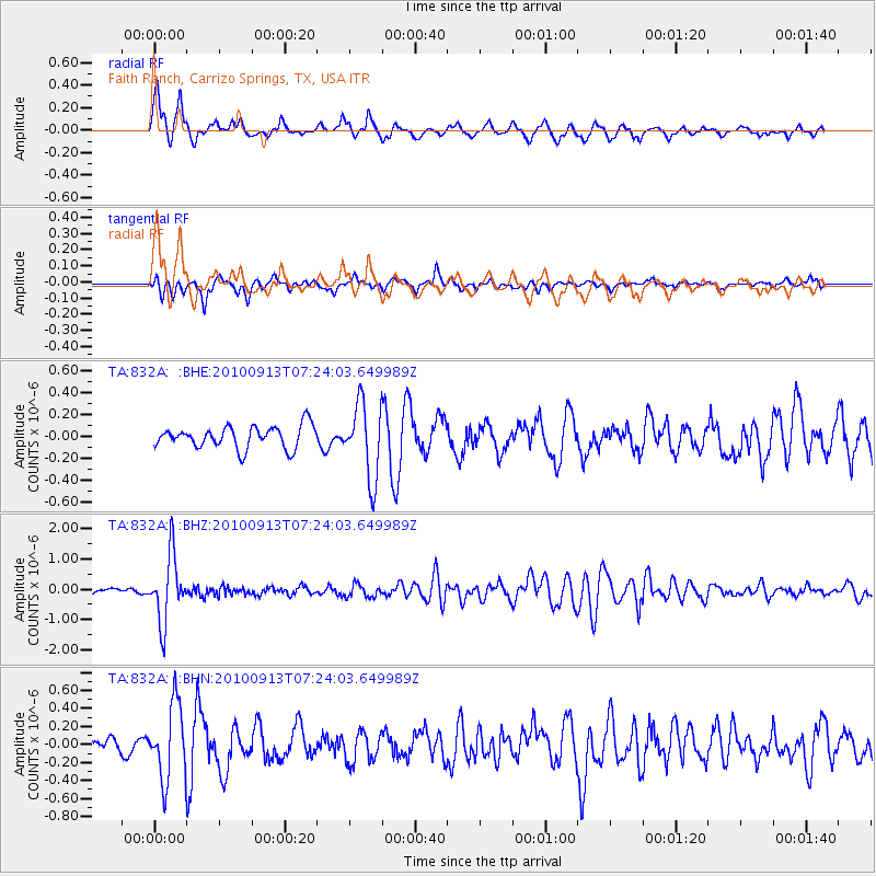
> Station 832A Faith Ranch, Carrizo Springs, TX, USA > Earthquake Result Viewer
832A Faith Ranch, Carrizo Springs, TX, USA - Earthquake Result Viewer
| Earthquake location: |
Central Peru |
| Earthquake latitude/longitude: |
-14.6/-70.8 |
| Earthquake time(UTC): |
2010/09/13 (256) 07:15:49 GMT |
| Earthquake Depth: |
180 km |
| Earthquake Magnitude: |
5.6 MB, 5.9 MW, 5.8 MW |
| Earthquake Catalog/Contributor: |
WHDF/NEIC |
|
| Network: |
TA USArray Transportable Network (new EarthScope stations) |
| Station: |
832A Faith Ranch, Carrizo Springs, TX, USA |
| Lat/Lon: |
28.28 N/99.97 W |
| Elevation: |
238 m |
|
| Distance: |
51.2 deg |
| Az: |
326.473 deg |
| Baz: |
142.679 deg |
| Ray Param: |
0.06695051 |
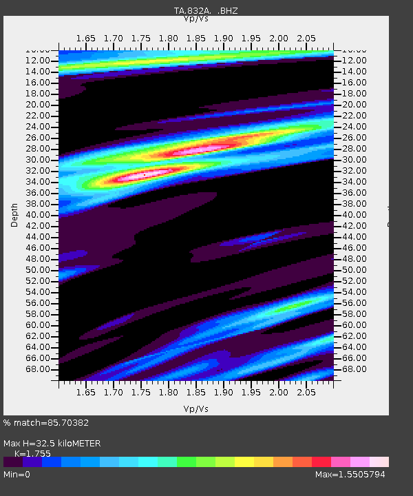
| Estimated Moho Depth: |
32.5 km |
| Estimated Crust Vp/Vs: |
1.75 |
| Assumed Crust Vp: |
6.347 km/s |
| Estimated Crust Vs: |
3.617 km/s |
| Estimated Crust Poisson's Ratio: |
0.26 |
|
| Radial Match: |
85.70382 % |
| Radial Bump: |
375 |
| Transverse Match: |
62.528145 % |
| Transverse Bump: |
389 |
| SOD ConfigId: |
319893 |
| Insert Time: |
2011-01-20 09:02:11.500 +0000 |
| GWidth: |
2.5 |
| Max Bumps: |
400 |
| Tol: |
0.001 |
|
Signal To Noise
| Channel | StoN | STA | LTA |
| TA:832A: :BHZ:20100913T07:24:03.649989Z | 10.614254 | 1.0945668E-6 | 1.0312234E-7 |
| TA:832A: :BHN:20100913T07:24:03.649989Z | 6.1515865 | 4.1562606E-7 | 6.7564045E-8 |
| TA:832A: :BHE:20100913T07:24:03.649989Z | 3.40776 | 3.4432753E-7 | 1.010422E-7 |
| Arrivals |
| Ps | 4.1 SECOND |
| PpPs | 13 SECOND |
| PsPs/PpSs | 17 SECOND |


