You are here: Home > Network List > TA - USArray Transportable Network (new EarthScope stations) Stations List
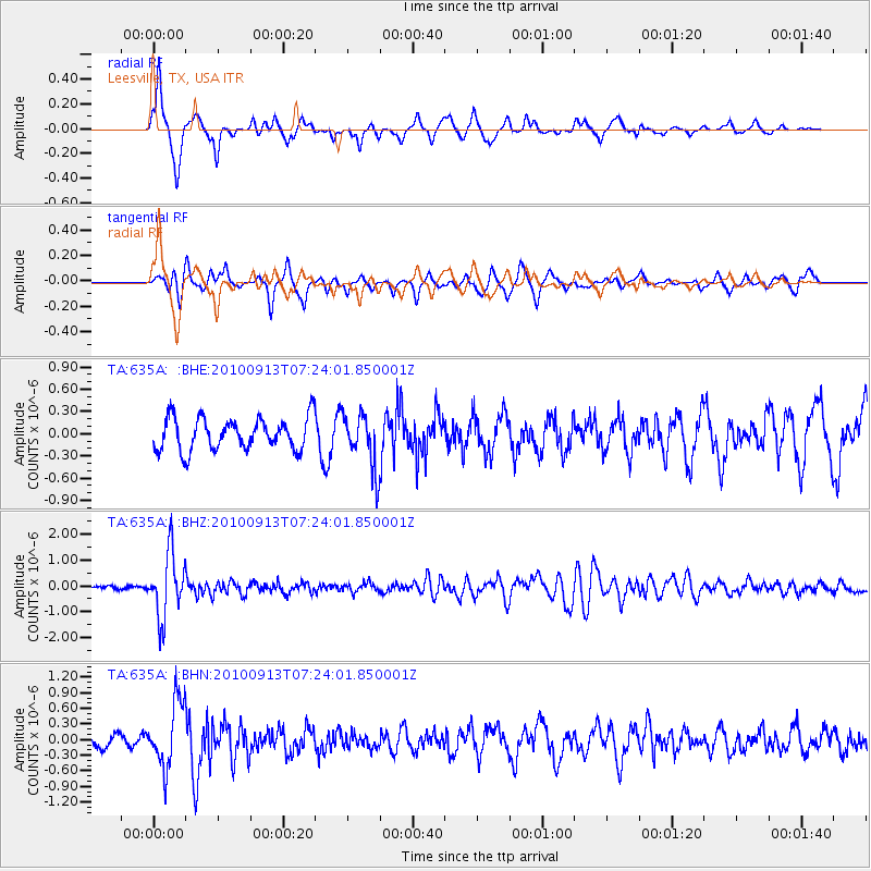
> Station 635A Leesville, TX, USA > Earthquake Result Viewer
635A Leesville, TX, USA - Earthquake Result Viewer
| Earthquake location: |
Central Peru |
| Earthquake latitude/longitude: |
-14.6/-70.8 |
| Earthquake time(UTC): |
2010/09/13 (256) 07:15:49 GMT |
| Earthquake Depth: |
180 km |
| Earthquake Magnitude: |
5.6 MB, 5.9 MW, 5.8 MW |
| Earthquake Catalog/Contributor: |
WHDF/NEIC |
|
| Network: |
TA USArray Transportable Network (new EarthScope stations) |
| Station: |
635A Leesville, TX, USA |
| Lat/Lon: |
29.39 N/97.77 W |
| Elevation: |
119 m |
|
| Distance: |
50.9 deg |
| Az: |
329.313 deg |
| Baz: |
145.522 deg |
| Ray Param: |
0.06710887 |
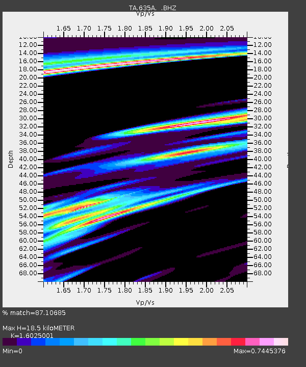
| Estimated Moho Depth: |
18.5 km |
| Estimated Crust Vp/Vs: |
1.60 |
| Assumed Crust Vp: |
5.78 km/s |
| Estimated Crust Vs: |
3.607 km/s |
| Estimated Crust Poisson's Ratio: |
0.18 |
|
| Radial Match: |
87.10685 % |
| Radial Bump: |
291 |
| Transverse Match: |
62.49409 % |
| Transverse Bump: |
337 |
| SOD ConfigId: |
319893 |
| Insert Time: |
2011-01-20 09:02:21.258 +0000 |
| GWidth: |
2.5 |
| Max Bumps: |
400 |
| Tol: |
0.001 |
|
Signal To Noise
| Channel | StoN | STA | LTA |
| TA:635A: :BHZ:20100913T07:24:01.850001Z | 11.999084 | 1.2305063E-6 | 1.0255001E-7 |
| TA:635A: :BHN:20100913T07:24:01.850001Z | 5.5013814 | 6.229976E-7 | 1.1324386E-7 |
| TA:635A: :BHE:20100913T07:24:01.850001Z | 1.6993024 | 3.688168E-7 | 2.1704012E-7 |
| Arrivals |
| Ps | 2.0 SECOND |
| PpPs | 7.9 SECOND |
| PsPs/PpSs | 10.0 SECOND |


