You are here: Home > Network List > TA - USArray Transportable Network (new EarthScope stations) Stations List
> Station 933A Laredo, TX, USA > Earthquake Result Viewer
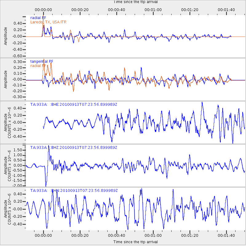
933A Laredo, TX, USA - Earthquake Result Viewer
*The percent match for this event was below the threshold and hence no stack was calculated.
| Earthquake location: |
Central Peru |
| Earthquake latitude/longitude: |
-14.6/-70.8 |
| Earthquake time(UTC): |
2010/09/13 (256) 07:15:49 GMT |
| Earthquake Depth: |
180 km |
| Earthquake Magnitude: |
5.6 MB, 5.9 MW, 5.8 MW |
| Earthquake Catalog/Contributor: |
WHDF/NEIC |
|
| Network: |
TA USArray Transportable Network (new EarthScope stations) |
| Station: |
933A Laredo, TX, USA |
| Lat/Lon: |
27.61 N/99.27 W |
| Elevation: |
214 m |
|
| Distance: |
50.3 deg |
| Az: |
326.59 deg |
| Baz: |
143.079 deg |
| Ray Param: |
$rayparam |
*The percent match for this event was below the threshold and hence was not used in the summary stack. |
|
| Radial Match: |
73.42227 % |
| Radial Bump: |
400 |
| Transverse Match: |
61.110825 % |
| Transverse Bump: |
400 |
| SOD ConfigId: |
319893 |
| Insert Time: |
2011-01-20 09:02:57.805 +0000 |
| GWidth: |
2.5 |
| Max Bumps: |
400 |
| Tol: |
0.001 |
|
Signal To Noise
| Channel | StoN | STA | LTA |
| TA:933A: :BHZ:20100913T07:23:56.899989Z | 10.770333 | 9.821407E-7 | 9.118945E-8 |
| TA:933A: :BHN:20100913T07:23:56.899989Z | 1.5733048 | 2.7782866E-7 | 1.7658923E-7 |
| TA:933A: :BHE:20100913T07:23:56.899989Z | 2.327487 | 1.8034126E-7 | 7.748325E-8 |
| Arrivals |
| Ps | |
| PpPs | |
| PsPs/PpSs | |


