You are here: Home > Network List > IW - Intermountain West Stations List
> Station MOOW Moose Ponds, Wyoming, USA > Earthquake Result Viewer
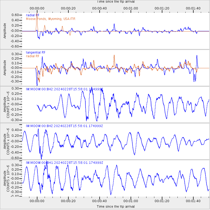
MOOW Moose Ponds, Wyoming, USA - Earthquake Result Viewer
*The percent match for this event was below the threshold and hence no stack was calculated.
| Earthquake location: |
Rat Islands, Aleutian Islands |
| Earthquake latitude/longitude: |
51.9/179.6 |
| Earthquake time(UTC): |
2024/02/28 (059) 15:50:21 GMT |
| Earthquake Depth: |
119 km |
| Earthquake Magnitude: |
5.5 mww |
| Earthquake Catalog/Contributor: |
NEIC PDE/us |
|
| Network: |
IW Intermountain West |
| Station: |
MOOW Moose Ponds, Wyoming, USA |
| Lat/Lon: |
43.75 N/110.74 W |
| Elevation: |
2128 m |
|
| Distance: |
45.8 deg |
| Az: |
71.405 deg |
| Baz: |
305.95 deg |
| Ray Param: |
$rayparam |
*The percent match for this event was below the threshold and hence was not used in the summary stack. |
|
| Radial Match: |
70.763565 % |
| Radial Bump: |
400 |
| Transverse Match: |
66.29504 % |
| Transverse Bump: |
400 |
| SOD ConfigId: |
33437571 |
| Insert Time: |
2024-03-16 00:18:50.722 +0000 |
| GWidth: |
2.5 |
| Max Bumps: |
400 |
| Tol: |
0.001 |
|
Signal To Noise
| Channel | StoN | STA | LTA |
| IW:MOOW:00:BHZ:20240228T15:58:01.174999Z | 1.7205255 | 3.3135944E-7 | 1.92592E-7 |
| IW:MOOW:00:BH1:20240228T15:58:01.174999Z | 1.449778 | 1.9841356E-7 | 1.368579E-7 |
| IW:MOOW:00:BH2:20240228T15:58:01.174999Z | 2.3821445 | 2.2082132E-7 | 9.2698535E-8 |
| Arrivals |
| Ps | |
| PpPs | |
| PsPs/PpSs | |


