You are here: Home > Network List > TA - USArray Transportable Network (new EarthScope stations) Stations List
> Station 339A Huntington, TX, USA > Earthquake Result Viewer
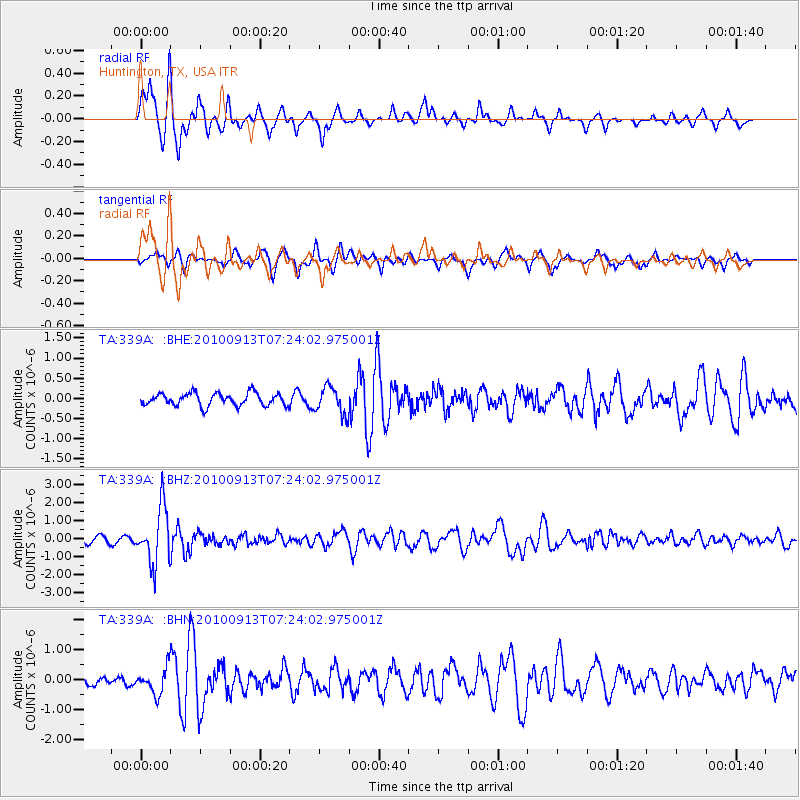
339A Huntington, TX, USA - Earthquake Result Viewer
*The percent match for this event was below the threshold and hence no stack was calculated.
| Earthquake location: |
Central Peru |
| Earthquake latitude/longitude: |
-14.6/-70.8 |
| Earthquake time(UTC): |
2010/09/13 (256) 07:15:49 GMT |
| Earthquake Depth: |
180 km |
| Earthquake Magnitude: |
5.6 MB, 5.9 MW, 5.8 MW |
| Earthquake Catalog/Contributor: |
WHDF/NEIC |
|
| Network: |
TA USArray Transportable Network (new EarthScope stations) |
| Station: |
339A Huntington, TX, USA |
| Lat/Lon: |
31.33 N/94.56 W |
| Elevation: |
82 m |
|
| Distance: |
51.1 deg |
| Az: |
333.672 deg |
| Baz: |
149.884 deg |
| Ray Param: |
$rayparam |
*The percent match for this event was below the threshold and hence was not used in the summary stack. |
|
| Radial Match: |
84.159485 % |
| Radial Bump: |
400 |
| Transverse Match: |
74.763054 % |
| Transverse Bump: |
400 |
| SOD ConfigId: |
319893 |
| Insert Time: |
2011-01-20 09:04:09.930 +0000 |
| GWidth: |
2.5 |
| Max Bumps: |
400 |
| Tol: |
0.001 |
|
Signal To Noise
| Channel | StoN | STA | LTA |
| TA:339A: :BHZ:20100913T07:24:02.975001Z | 10.246179 | 1.5688158E-6 | 1.5311228E-7 |
| TA:339A: :BHN:20100913T07:24:02.975001Z | 2.1820843 | 4.2974594E-7 | 1.9694288E-7 |
| TA:339A: :BHE:20100913T07:24:02.975001Z | 2.1824071 | 3.3596237E-7 | 1.5394119E-7 |
| Arrivals |
| Ps | |
| PpPs | |
| PsPs/PpSs | |


