You are here: Home > Network List > AZ - ANZA Regional Network Stations List
> Station CRY AZ.CRY > Earthquake Result Viewer
CRY AZ.CRY - Earthquake Result Viewer
| Earthquake location: |
Kermadec Islands Region |
| Earthquake latitude/longitude: |
-31.9/-179.0 |
| Earthquake time(UTC): |
1999/04/20 (110) 19:04:08 GMT |
| Earthquake Depth: |
96 km |
| Earthquake Magnitude: |
6.2 MB, 6.5 MW, 6.5 MW |
| Earthquake Catalog/Contributor: |
WHDF/NEIC |
|
| Network: |
AZ ANZA Regional Network |
| Station: |
CRY AZ.CRY |
| Lat/Lon: |
33.57 N/116.74 W |
| Elevation: |
1128 m |
|
| Distance: |
87.7 deg |
| Az: |
47.723 deg |
| Baz: |
228.923 deg |
| Ray Param: |
0.042965673 |
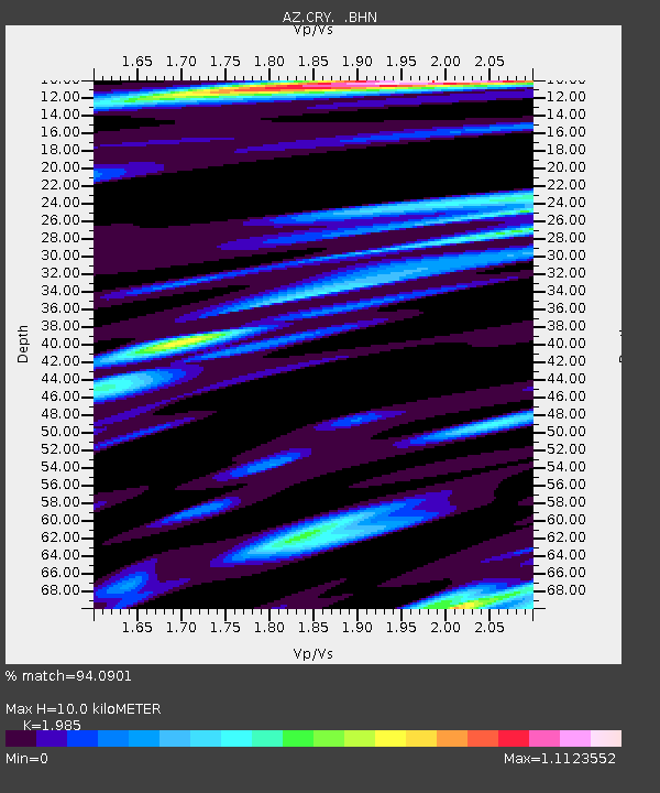
| Estimated Moho Depth: |
10.0 km |
| Estimated Crust Vp/Vs: |
1.99 |
| Assumed Crust Vp: |
6.264 km/s |
| Estimated Crust Vs: |
3.155 km/s |
| Estimated Crust Poisson's Ratio: |
0.33 |
|
| Radial Match: |
94.0901 % |
| Radial Bump: |
400 |
| Transverse Match: |
85.280304 % |
| Transverse Bump: |
400 |
| SOD ConfigId: |
32974 |
| Insert Time: |
2010-02-26 18:58:56.107 +0000 |
| GWidth: |
2.5 |
| Max Bumps: |
400 |
| Tol: |
0.001 |
|
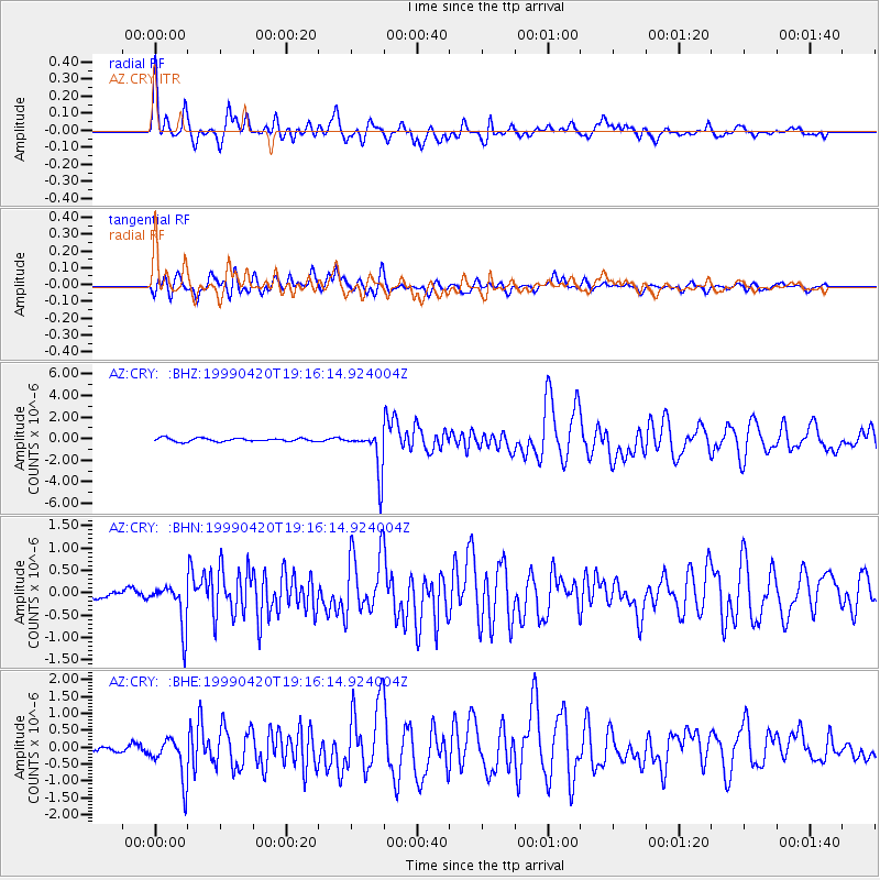
Signal To Noise
| Channel | StoN | STA | LTA |
| AZ:CRY: :BHN:19990420T19:16:14.924004Z | 3.2947528 | 4.8820635E-7 | 1.4817692E-7 |
| AZ:CRY: :BHE:19990420T19:16:14.924004Z | 3.9229386 | 6.3740794E-7 | 1.6248227E-7 |
| AZ:CRY: :BHZ:19990420T19:16:14.924004Z | 12.658238 | 1.9704955E-6 | 1.5566903E-7 |
| Arrivals |
| Ps | 1.6 SECOND |
| PpPs | 4.7 SECOND |
| PsPs/PpSs | 6.3 SECOND |


