You are here: Home > Network List > TA - USArray Transportable Network (new EarthScope stations) Stations List
> Station Y37A Hugo, OK, USA > Earthquake Result Viewer
Y37A Hugo, OK, USA - Earthquake Result Viewer

| Earthquake location: |
Central Peru |
| Earthquake latitude/longitude: |
-14.6/-70.8 |
| Earthquake time(UTC): |
2010/09/13 (256) 07:15:49 GMT |
| Earthquake Depth: |
180 km |
| Earthquake Magnitude: |
5.6 MB, 5.9 MW, 5.8 MW |
| Earthquake Catalog/Contributor: |
WHDF/NEIC |
|
| Network: |
TA USArray Transportable Network (new EarthScope stations) |
| Station: |
Y37A Hugo, OK, USA |
| Lat/Lon: |
33.98 N/95.62 W |
| Elevation: |
165 m |
|
| Distance: |
53.8 deg |
| Az: |
334.366 deg |
| Baz: |
149.735 deg |
| Ray Param: |
0.06525254 |
| Estimated Moho Depth: |
13.75 km |
| Estimated Crust Vp/Vs: |
1.76 |
| Assumed Crust Vp: |
6.245 km/s |
| Estimated Crust Vs: |
3.553 km/s |
| Estimated Crust Poisson's Ratio: |
0.26 |
|
| Radial Match: |
91.30162 % |
| Radial Bump: |
400 |
| Transverse Match: |
68.08742 % |
| Transverse Bump: |
400 |
| SOD ConfigId: |
319893 |
| Insert Time: |
2011-01-20 09:06:44.538 +0000 |
| GWidth: |
2.5 |
| Max Bumps: |
400 |
| Tol: |
0.001 |
|
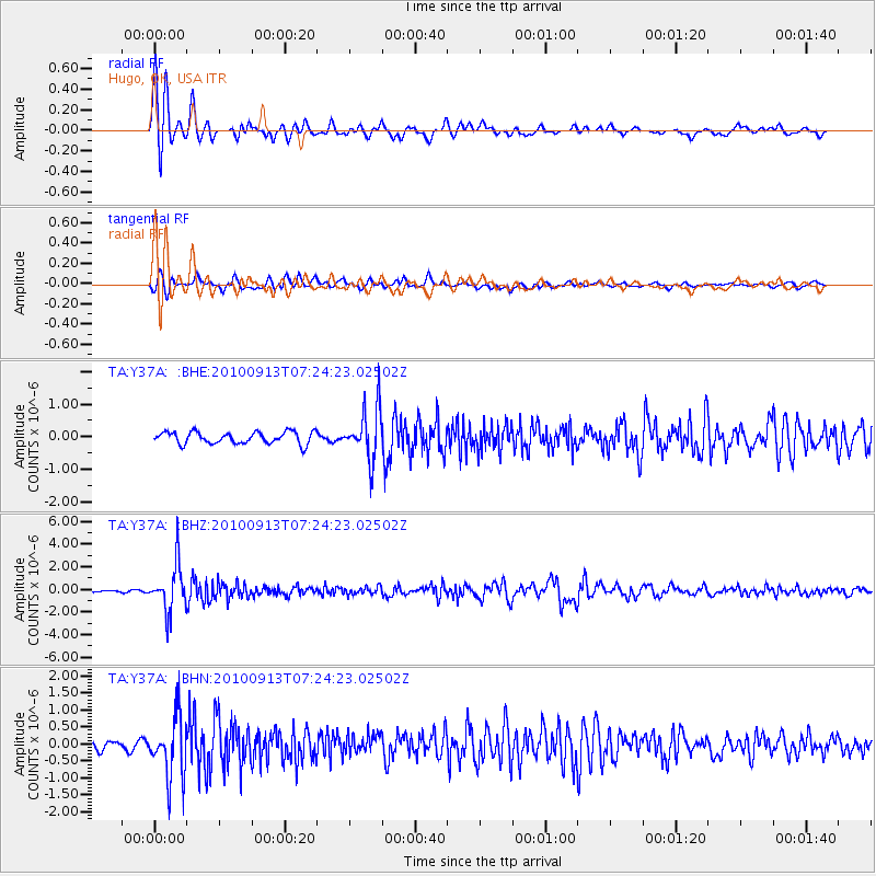
Signal To Noise
| Channel | StoN | STA | LTA |
| TA:Y37A: :BHZ:20100913T07:24:23.02502Z | 19.304686 | 2.034926E-6 | 1.0541099E-7 |
| TA:Y37A: :BHN:20100913T07:24:23.02502Z | 6.2920485 | 8.88488E-7 | 1.4120806E-7 |
| TA:Y37A: :BHE:20100913T07:24:23.02502Z | 4.233053 | 7.716998E-7 | 1.8230335E-7 |
| Arrivals |
| Ps | 1.8 SECOND |
| PpPs | 5.8 SECOND |
| PsPs/PpSs | 7.5 SECOND |


