You are here: Home > Network List > TA - USArray Transportable Network (new EarthScope stations) Stations List
> Station 139A Bunkhouse Ranch, Marshall, TX, USA > Earthquake Result Viewer
139A Bunkhouse Ranch, Marshall, TX, USA - Earthquake Result Viewer
| Earthquake location: |
Central Peru |
| Earthquake latitude/longitude: |
-14.6/-70.8 |
| Earthquake time(UTC): |
2010/09/13 (256) 07:15:49 GMT |
| Earthquake Depth: |
180 km |
| Earthquake Magnitude: |
5.6 MB, 5.9 MW, 5.8 MW |
| Earthquake Catalog/Contributor: |
WHDF/NEIC |
|
| Network: |
TA USArray Transportable Network (new EarthScope stations) |
| Station: |
139A Bunkhouse Ranch, Marshall, TX, USA |
| Lat/Lon: |
32.68 N/94.39 W |
| Elevation: |
59 m |
|
| Distance: |
52.2 deg |
| Az: |
334.675 deg |
| Baz: |
150.593 deg |
| Ray Param: |
0.06630423 |
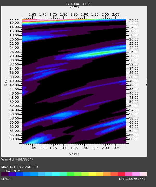
| Estimated Moho Depth: |
10.0 km |
| Estimated Crust Vp/Vs: |
1.77 |
| Assumed Crust Vp: |
6.245 km/s |
| Estimated Crust Vs: |
3.533 km/s |
| Estimated Crust Poisson's Ratio: |
0.26 |
|
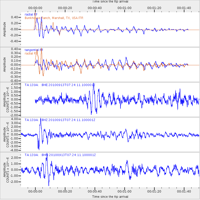
| Radial Match: |
84.38047 % |
| Radial Bump: |
374 |
| Transverse Match: |
80.830574 % |
| Transverse Bump: |
400 |
| SOD ConfigId: |
319893 |
| Insert Time: |
2011-01-20 09:06:57.330 +0000 |
| GWidth: |
2.5 |
| Max Bumps: |
400 |
| Tol: |
0.001 |
|
Signal To Noise
| Channel | StoN | STA | LTA |
| TA:139A: :BHZ:20100913T07:24:11.100001Z | 11.791719 | 1.888219E-6 | 1.6013094E-7 |
| TA:139A: :BHN:20100913T07:24:11.100001Z | 2.1706228 | 5.7433516E-7 | 2.6459463E-7 |
| TA:139A: :BHE:20100913T07:24:11.100001Z | 1.2223086 | 3.1953599E-7 | 2.6142007E-7 |
| Arrivals |
| Ps | 1.3 SECOND |
| PpPs | 4.2 SECOND |
| PsPs/PpSs | 5.5 SECOND |


