You are here: Home > Network List > US - United States National Seismic Network Stations List
> Station AGMN Agassiz National Wildlife Refuge, Minnesota, USA > Earthquake Result Viewer
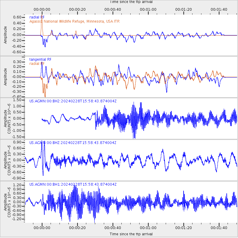
AGMN Agassiz National Wildlife Refuge, Minnesota, USA - Earthquake Result Viewer
*The percent match for this event was below the threshold and hence no stack was calculated.
| Earthquake location: |
Rat Islands, Aleutian Islands |
| Earthquake latitude/longitude: |
51.9/179.6 |
| Earthquake time(UTC): |
2024/02/28 (059) 15:50:21 GMT |
| Earthquake Depth: |
119 km |
| Earthquake Magnitude: |
5.5 mww |
| Earthquake Catalog/Contributor: |
NEIC PDE/us |
|
| Network: |
US United States National Seismic Network |
| Station: |
AGMN Agassiz National Wildlife Refuge, Minnesota, USA |
| Lat/Lon: |
48.30 N/95.86 W |
| Elevation: |
351 m |
|
| Distance: |
51.4 deg |
| Az: |
58.283 deg |
| Baz: |
307.953 deg |
| Ray Param: |
$rayparam |
*The percent match for this event was below the threshold and hence was not used in the summary stack. |
|
| Radial Match: |
66.25183 % |
| Radial Bump: |
400 |
| Transverse Match: |
56.000355 % |
| Transverse Bump: |
400 |
| SOD ConfigId: |
33437571 |
| Insert Time: |
2024-03-16 00:32:55.929 +0000 |
| GWidth: |
2.5 |
| Max Bumps: |
400 |
| Tol: |
0.001 |
|
Signal To Noise
| Channel | StoN | STA | LTA |
| US:AGMN:00:BHZ:20240228T15:58:43.874004Z | 1.5174865 | 4.696429E-7 | 3.094874E-7 |
| US:AGMN:00:BH1:20240228T15:58:43.874004Z | 1.3997124 | 3.7237626E-7 | 2.660377E-7 |
| US:AGMN:00:BH2:20240228T15:58:43.874004Z | 2.2489147 | 3.8983617E-7 | 1.7334413E-7 |
| Arrivals |
| Ps | |
| PpPs | |
| PsPs/PpSs | |


