You are here: Home > Network List > US - United States National Seismic Network Stations List
> Station CBKS Cedar Bluff, Kansas, USA > Earthquake Result Viewer
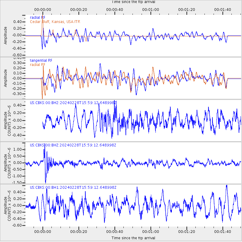
CBKS Cedar Bluff, Kansas, USA - Earthquake Result Viewer
*The percent match for this event was below the threshold and hence no stack was calculated.
| Earthquake location: |
Rat Islands, Aleutian Islands |
| Earthquake latitude/longitude: |
51.9/179.6 |
| Earthquake time(UTC): |
2024/02/28 (059) 15:50:21 GMT |
| Earthquake Depth: |
119 km |
| Earthquake Magnitude: |
5.5 mww |
| Earthquake Catalog/Contributor: |
NEIC PDE/us |
|
| Network: |
US United States National Seismic Network |
| Station: |
CBKS Cedar Bluff, Kansas, USA |
| Lat/Lon: |
38.81 N/99.74 W |
| Elevation: |
677 m |
|
| Distance: |
55.3 deg |
| Az: |
69.593 deg |
| Baz: |
312.049 deg |
| Ray Param: |
$rayparam |
*The percent match for this event was below the threshold and hence was not used in the summary stack. |
|
| Radial Match: |
54.73484 % |
| Radial Bump: |
400 |
| Transverse Match: |
49.62157 % |
| Transverse Bump: |
400 |
| SOD ConfigId: |
33437571 |
| Insert Time: |
2024-03-16 00:33:03.091 +0000 |
| GWidth: |
2.5 |
| Max Bumps: |
400 |
| Tol: |
0.001 |
|
Signal To Noise
| Channel | StoN | STA | LTA |
| US:CBKS:00:BHZ:20240228T15:59:12.648998Z | 3.458386 | 6.178085E-7 | 1.786407E-7 |
| US:CBKS:00:BH1:20240228T15:59:12.648998Z | 1.6237633 | 2.448049E-7 | 1.5076392E-7 |
| US:CBKS:00:BH2:20240228T15:59:12.648998Z | 1.4411734 | 2.321703E-7 | 1.6109809E-7 |
| Arrivals |
| Ps | |
| PpPs | |
| PsPs/PpSs | |


