You are here: Home > Network List > UU - University of Utah Regional Network Stations List
> Station FORU South Mineral Mountains, UT, USA > Earthquake Result Viewer
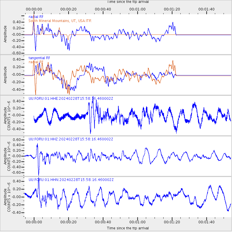
FORU South Mineral Mountains, UT, USA - Earthquake Result Viewer
*The percent match for this event was below the threshold and hence no stack was calculated.
| Earthquake location: |
Rat Islands, Aleutian Islands |
| Earthquake latitude/longitude: |
51.9/179.6 |
| Earthquake time(UTC): |
2024/02/28 (059) 15:50:21 GMT |
| Earthquake Depth: |
119 km |
| Earthquake Magnitude: |
5.5 mww |
| Earthquake Catalog/Contributor: |
NEIC PDE/us |
|
| Network: |
UU University of Utah Regional Network |
| Station: |
FORU South Mineral Mountains, UT, USA |
| Lat/Lon: |
38.46 N/112.86 W |
| Elevation: |
1840 m |
|
| Distance: |
47.8 deg |
| Az: |
78.488 deg |
| Baz: |
309.416 deg |
| Ray Param: |
$rayparam |
*The percent match for this event was below the threshold and hence was not used in the summary stack. |
|
| Radial Match: |
45.81058 % |
| Radial Bump: |
400 |
| Transverse Match: |
62.331333 % |
| Transverse Bump: |
400 |
| SOD ConfigId: |
33437571 |
| Insert Time: |
2024-03-16 00:33:57.789 +0000 |
| GWidth: |
2.5 |
| Max Bumps: |
400 |
| Tol: |
0.001 |
|
Signal To Noise
| Channel | StoN | STA | LTA |
| UU:FORU:01:HHZ:20240228T15:58:16.460002Z | 5.557279 | 2.5631488E-7 | 4.6122366E-8 |
| UU:FORU:01:HHN:20240228T15:58:16.460002Z | 3.0350974 | 2.0606744E-7 | 6.789484E-8 |
| UU:FORU:01:HHE:20240228T15:58:16.460002Z | 2.4817138 | 2.6896774E-7 | 1.0837983E-7 |
| Arrivals |
| Ps | |
| PpPs | |
| PsPs/PpSs | |


