You are here: Home > Network List > TA - USArray Transportable Network (new EarthScope stations) Stations List
> Station U36A Oologah, OK, USA > Earthquake Result Viewer
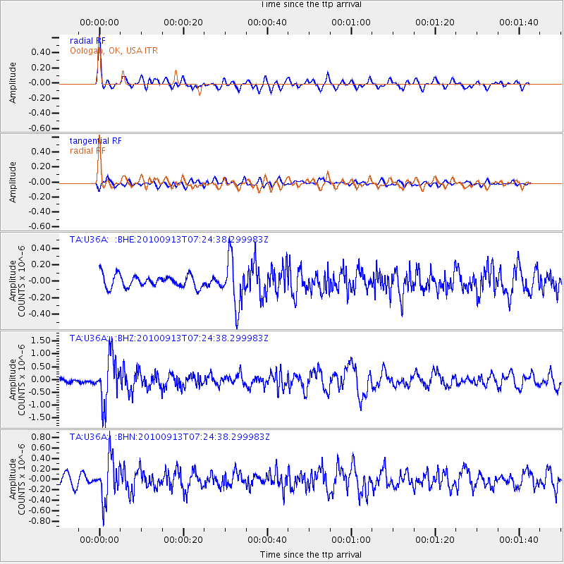
U36A Oologah, OK, USA - Earthquake Result Viewer
*The percent match for this event was below the threshold and hence no stack was calculated.
| Earthquake location: |
Central Peru |
| Earthquake latitude/longitude: |
-14.6/-70.8 |
| Earthquake time(UTC): |
2010/09/13 (256) 07:15:49 GMT |
| Earthquake Depth: |
180 km |
| Earthquake Magnitude: |
5.6 MB, 5.9 MW, 5.8 MW |
| Earthquake Catalog/Contributor: |
WHDF/NEIC |
|
| Network: |
TA USArray Transportable Network (new EarthScope stations) |
| Station: |
U36A Oologah, OK, USA |
| Lat/Lon: |
36.39 N/95.73 W |
| Elevation: |
187 m |
|
| Distance: |
55.9 deg |
| Az: |
335.737 deg |
| Baz: |
150.46 deg |
| Ray Param: |
$rayparam |
*The percent match for this event was below the threshold and hence was not used in the summary stack. |
|
| Radial Match: |
78.546104 % |
| Radial Bump: |
400 |
| Transverse Match: |
54.60859 % |
| Transverse Bump: |
400 |
| SOD ConfigId: |
319893 |
| Insert Time: |
2011-01-20 09:10:30.496 +0000 |
| GWidth: |
2.5 |
| Max Bumps: |
400 |
| Tol: |
0.001 |
|
Signal To Noise
| Channel | StoN | STA | LTA |
| TA:U36A: :BHZ:20100913T07:24:38.299983Z | 9.761221 | 8.957328E-7 | 9.176442E-8 |
| TA:U36A: :BHN:20100913T07:24:38.299983Z | 3.4647646 | 4.0302467E-7 | 1.1632093E-7 |
| TA:U36A: :BHE:20100913T07:24:38.299983Z | 3.9389405 | 2.9225282E-7 | 7.4195796E-8 |
| Arrivals |
| Ps | |
| PpPs | |
| PsPs/PpSs | |


