You are here: Home > Network List > TA - USArray Transportable Network (new EarthScope stations) Stations List
> Station O03D Paynes Creek, CA, USA > Earthquake Result Viewer
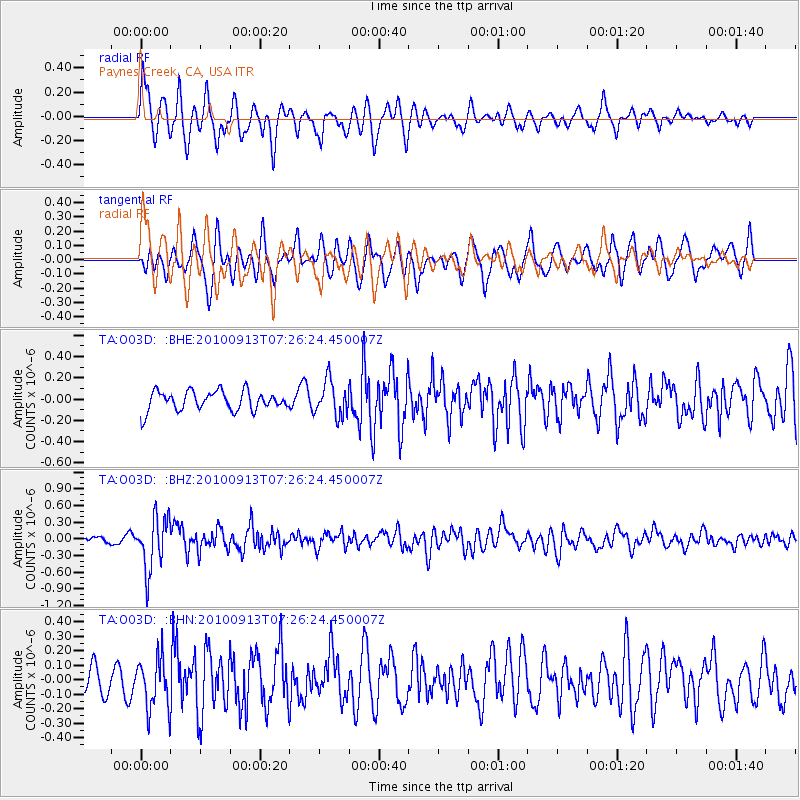
O03D Paynes Creek, CA, USA - Earthquake Result Viewer
*The percent match for this event was below the threshold and hence no stack was calculated.
| Earthquake location: |
Central Peru |
| Earthquake latitude/longitude: |
-14.6/-70.8 |
| Earthquake time(UTC): |
2010/09/13 (256) 07:15:49 GMT |
| Earthquake Depth: |
180 km |
| Earthquake Magnitude: |
5.6 MB, 5.9 MW, 5.8 MW |
| Earthquake Catalog/Contributor: |
WHDF/NEIC |
|
| Network: |
TA USArray Transportable Network (new EarthScope stations) |
| Station: |
O03D Paynes Creek, CA, USA |
| Lat/Lon: |
40.29 N/121.80 W |
| Elevation: |
968 m |
|
| Distance: |
72.3 deg |
| Az: |
321.376 deg |
| Baz: |
127.81 deg |
| Ray Param: |
$rayparam |
*The percent match for this event was below the threshold and hence was not used in the summary stack. |
|
| Radial Match: |
73.87154 % |
| Radial Bump: |
400 |
| Transverse Match: |
65.30889 % |
| Transverse Bump: |
400 |
| SOD ConfigId: |
319893 |
| Insert Time: |
2011-01-20 09:12:24.296 +0000 |
| GWidth: |
2.5 |
| Max Bumps: |
400 |
| Tol: |
0.001 |
|
Signal To Noise
| Channel | StoN | STA | LTA |
| TA:O03D: :BHZ:20100913T07:26:24.450007Z | 13.406143 | 4.7687445E-7 | 3.557134E-8 |
| TA:O03D: :BHN:20100913T07:26:24.450007Z | 2.3968172 | 1.752436E-7 | 7.311513E-8 |
| TA:O03D: :BHE:20100913T07:26:24.450007Z | 1.8213166 | 1.6489412E-7 | 9.053568E-8 |
| Arrivals |
| Ps | |
| PpPs | |
| PsPs/PpSs | |


