You are here: Home > Network List > US - United States National Seismic Network Stations List
> Station HAWA Hanford, Washington, USA > Earthquake Result Viewer
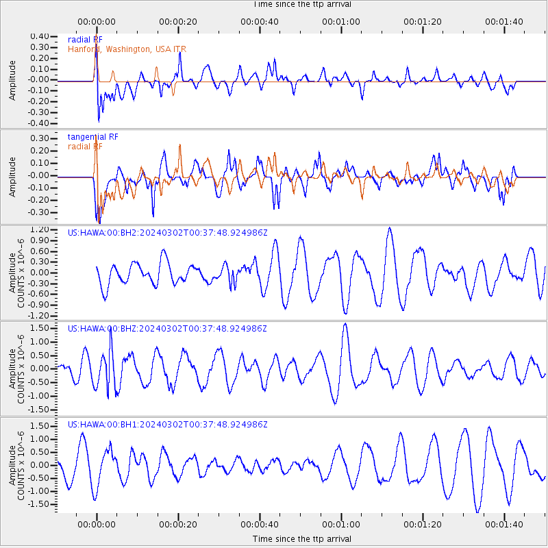
HAWA Hanford, Washington, USA - Earthquake Result Viewer
*The percent match for this event was below the threshold and hence no stack was calculated.
| Earthquake location: |
Fiji Islands Region |
| Earthquake latitude/longitude: |
-20.6/-178.4 |
| Earthquake time(UTC): |
2024/03/02 (062) 00:26:40 GMT |
| Earthquake Depth: |
537 km |
| Earthquake Magnitude: |
5.8 mww |
| Earthquake Catalog/Contributor: |
NEIC PDE/us |
|
| Network: |
US United States National Seismic Network |
| Station: |
HAWA Hanford, Washington, USA |
| Lat/Lon: |
46.39 N/119.53 W |
| Elevation: |
364 m |
|
| Distance: |
85.2 deg |
| Az: |
36.478 deg |
| Baz: |
233.595 deg |
| Ray Param: |
$rayparam |
*The percent match for this event was below the threshold and hence was not used in the summary stack. |
|
| Radial Match: |
66.44238 % |
| Radial Bump: |
400 |
| Transverse Match: |
58.25028 % |
| Transverse Bump: |
400 |
| SOD ConfigId: |
33437571 |
| Insert Time: |
2024-03-16 00:59:30.182 +0000 |
| GWidth: |
2.5 |
| Max Bumps: |
400 |
| Tol: |
0.001 |
|
Signal To Noise
| Channel | StoN | STA | LTA |
| US:HAWA:00:BHZ:20240302T00:37:48.924986Z | 2.5954893 | 6.9797096E-7 | 2.6891692E-7 |
| US:HAWA:00:BH1:20240302T00:37:48.924986Z | 1.5709273 | 7.2292664E-7 | 4.6019102E-7 |
| US:HAWA:00:BH2:20240302T00:37:48.924986Z | 0.7573261 | 2.2244811E-7 | 2.937283E-7 |
| Arrivals |
| Ps | |
| PpPs | |
| PsPs/PpSs | |


