You are here: Home > Network List > UW - Pacific Northwest Regional Seismic Network Stations List
> Station UMAT Pilot Rock, OR, USA > Earthquake Result Viewer
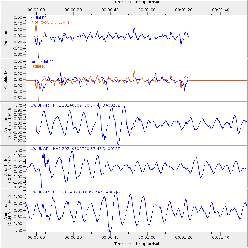
UMAT Pilot Rock, OR, USA - Earthquake Result Viewer
*The percent match for this event was below the threshold and hence no stack was calculated.
| Earthquake location: |
Fiji Islands Region |
| Earthquake latitude/longitude: |
-20.6/-178.4 |
| Earthquake time(UTC): |
2024/03/02 (062) 00:26:40 GMT |
| Earthquake Depth: |
537 km |
| Earthquake Magnitude: |
5.8 mww |
| Earthquake Catalog/Contributor: |
NEIC PDE/us |
|
| Network: |
UW Pacific Northwest Regional Seismic Network |
| Station: |
UMAT Pilot Rock, OR, USA |
| Lat/Lon: |
45.29 N/118.96 W |
| Elevation: |
1318 m |
|
| Distance: |
84.9 deg |
| Az: |
37.608 deg |
| Baz: |
234.102 deg |
| Ray Param: |
$rayparam |
*The percent match for this event was below the threshold and hence was not used in the summary stack. |
|
| Radial Match: |
72.90527 % |
| Radial Bump: |
400 |
| Transverse Match: |
73.2248 % |
| Transverse Bump: |
258 |
| SOD ConfigId: |
33437571 |
| Insert Time: |
2024-03-16 01:01:34.768 +0000 |
| GWidth: |
2.5 |
| Max Bumps: |
400 |
| Tol: |
0.001 |
|
Signal To Noise
| Channel | StoN | STA | LTA |
| UW:UMAT: :HHZ:20240302T00:37:47.340025Z | 1.9378875 | 7.5327296E-7 | 3.887083E-7 |
| UW:UMAT: :HHN:20240302T00:37:47.340025Z | 0.8423385 | 3.171908E-7 | 3.7655977E-7 |
| UW:UMAT: :HHE:20240302T00:37:47.340025Z | 1.3458207 | 6.473163E-7 | 4.809826E-7 |
| Arrivals |
| Ps | |
| PpPs | |
| PsPs/PpSs | |


