You are here: Home > Network List > AU - Australian Seismological Centre Stations List
> Station KLBR Kellerberrin, Western Australia > Earthquake Result Viewer
KLBR Kellerberrin, Western Australia - Earthquake Result Viewer
| Earthquake location: |
Macquarie Island Region |
| Earthquake latitude/longitude: |
-59.3/158.9 |
| Earthquake time(UTC): |
2024/03/03 (063) 16:16:57 GMT |
| Earthquake Depth: |
10 km |
| Earthquake Magnitude: |
6.7 mww |
| Earthquake Catalog/Contributor: |
NEIC PDE/us |
|
| Network: |
AU Australian Seismological Centre |
| Station: |
KLBR Kellerberrin, Western Australia |
| Lat/Lon: |
31.59 S/117.75 E |
| Elevation: |
320 m |
|
| Distance: |
39.0 deg |
| Az: |
296.927 deg |
| Baz: |
147.627 deg |
| Ray Param: |
0.07526359 |
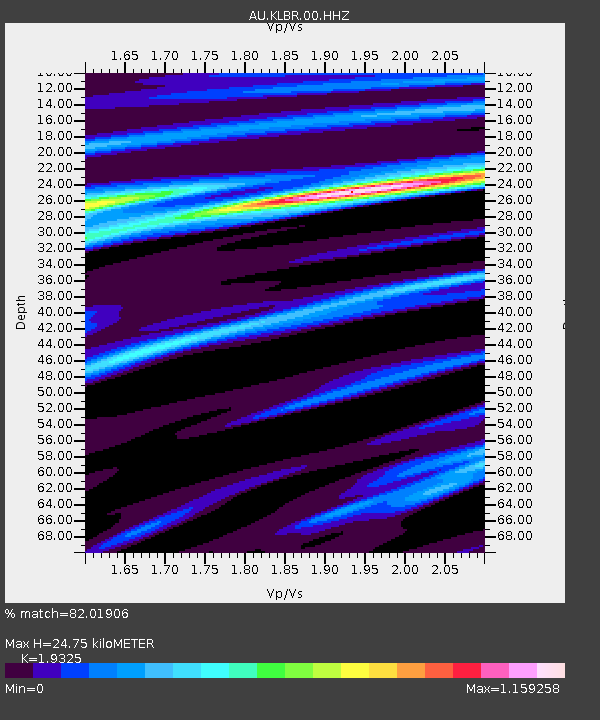
| Estimated Moho Depth: |
24.75 km |
| Estimated Crust Vp/Vs: |
1.93 |
| Assumed Crust Vp: |
6.419 km/s |
| Estimated Crust Vs: |
3.322 km/s |
| Estimated Crust Poisson's Ratio: |
0.32 |
|
| Radial Match: |
82.01906 % |
| Radial Bump: |
306 |
| Transverse Match: |
49.1857 % |
| Transverse Bump: |
400 |
| SOD ConfigId: |
33437571 |
| Insert Time: |
2024-03-17 16:19:06.561 +0000 |
| GWidth: |
2.5 |
| Max Bumps: |
400 |
| Tol: |
0.001 |
|

Signal To Noise
| Channel | StoN | STA | LTA |
| AU:KLBR:00:HHZ:20240303T16:23:52.884985Z | 2.6802924 | 7.240513E-7 | 2.701389E-7 |
| AU:KLBR:00:HHN:20240303T16:23:52.884985Z | 1.7686908 | 4.2225335E-7 | 2.3873778E-7 |
| AU:KLBR:00:HHE:20240303T16:23:52.884985Z | 1.0648674 | 3.855209E-7 | 3.6203656E-7 |
| Arrivals |
| Ps | 3.8 SECOND |
| PpPs | 11 SECOND |
| PsPs/PpSs | 14 SECOND |


