You are here: Home > Network List > US - United States National Seismic Network Stations List
> Station MSO Missoula, Montana, USA > Earthquake Result Viewer
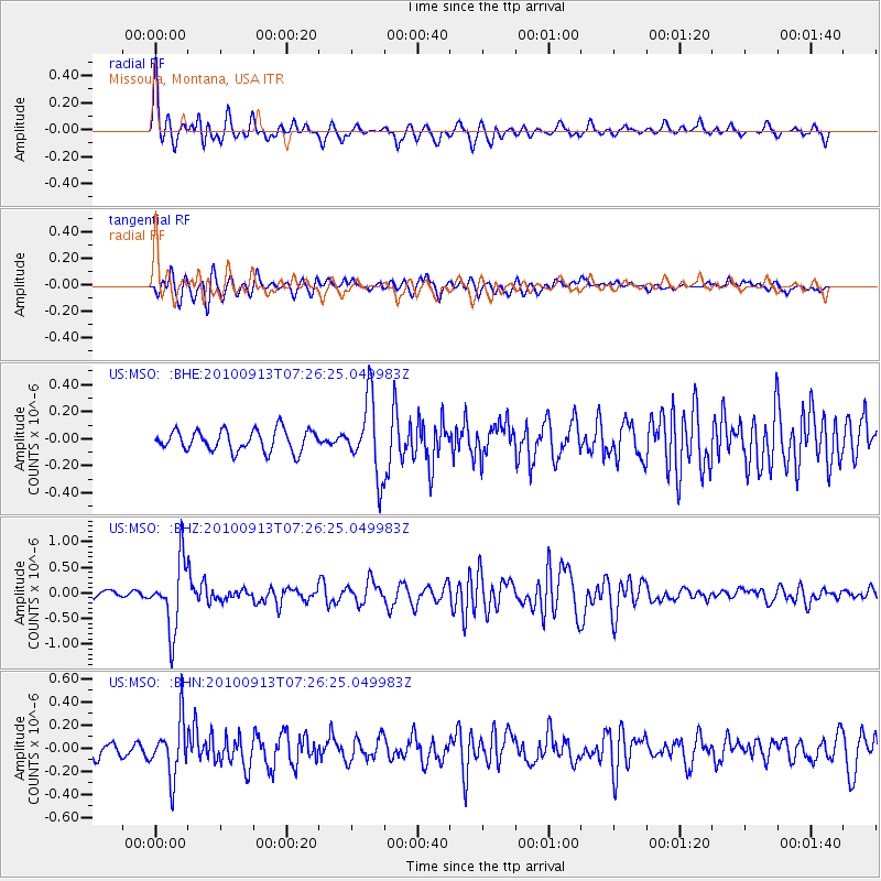
MSO Missoula, Montana, USA - Earthquake Result Viewer
*The percent match for this event was below the threshold and hence no stack was calculated.
| Earthquake location: |
Central Peru |
| Earthquake latitude/longitude: |
-14.6/-70.8 |
| Earthquake time(UTC): |
2010/09/13 (256) 07:15:49 GMT |
| Earthquake Depth: |
180 km |
| Earthquake Magnitude: |
5.6 MB, 5.9 MW, 5.8 MW |
| Earthquake Catalog/Contributor: |
WHDF/NEIC |
|
| Network: |
US United States National Seismic Network |
| Station: |
MSO Missoula, Montana, USA |
| Lat/Lon: |
46.83 N/113.94 W |
| Elevation: |
1264 m |
|
| Distance: |
72.4 deg |
| Az: |
330.475 deg |
| Baz: |
135.988 deg |
| Ray Param: |
$rayparam |
*The percent match for this event was below the threshold and hence was not used in the summary stack. |
|
| Radial Match: |
73.72757 % |
| Radial Bump: |
400 |
| Transverse Match: |
63.19815 % |
| Transverse Bump: |
400 |
| SOD ConfigId: |
319893 |
| Insert Time: |
2011-01-20 09:17:07.732 +0000 |
| GWidth: |
2.5 |
| Max Bumps: |
400 |
| Tol: |
0.001 |
|
Signal To Noise
| Channel | StoN | STA | LTA |
| US:MSO: :BHZ:20100913T07:26:25.049983Z | 11.152368 | 6.60533E-7 | 5.9228046E-8 |
| US:MSO: :BHN:20100913T07:26:25.049983Z | 3.0225997 | 2.3978933E-7 | 7.933215E-8 |
| US:MSO: :BHE:20100913T07:26:25.049983Z | 3.5528026 | 2.7550263E-7 | 7.754516E-8 |
| Arrivals |
| Ps | |
| PpPs | |
| PsPs/PpSs | |


