You are here: Home > Network List > AZ - ANZA Regional Network Stations List
> Station CRY AZ.CRY > Earthquake Result Viewer
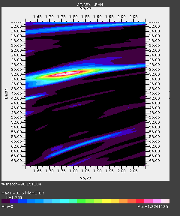
CRY AZ.CRY - Earthquake Result Viewer
| Earthquake location: |
East Of Kuril Islands |
| Earthquake latitude/longitude: |
46.2/154.5 |
| Earthquake time(UTC): |
2007/01/13 (013) 04:23:21 GMT |
| Earthquake Depth: |
10 km |
| Earthquake Magnitude: |
7.3 MB, 8.2 MS, 8.1 MW, 7.9 MW |
| Earthquake Catalog/Contributor: |
WHDF/NEIC |
|
| Network: |
AZ ANZA Regional Network |
| Station: |
CRY AZ.CRY |
| Lat/Lon: |
33.57 N/116.74 W |
| Elevation: |
1128 m |
|
| Distance: |
65.9 deg |
| Az: |
66.17 deg |
| Baz: |
310.506 deg |
| Ray Param: |
0.05799417 |
| Estimated Moho Depth: |
31.5 km |
| Estimated Crust Vp/Vs: |
1.76 |
| Assumed Crust Vp: |
6.264 km/s |
| Estimated Crust Vs: |
3.549 km/s |
| Estimated Crust Poisson's Ratio: |
0.26 |
|
| Radial Match: |
98.151184 % |
| Radial Bump: |
294 |
| Transverse Match: |
92.525696 % |
| Transverse Bump: |
400 |
| SOD ConfigId: |
2564 |
| Insert Time: |
2010-02-26 18:59:18.458 +0000 |
| GWidth: |
2.5 |
| Max Bumps: |
400 |
| Tol: |
0.001 |
|

Signal To Noise
| Channel | StoN | STA | LTA |
| AZ:CRY: :BHN:20070113T04:33:35.625027Z | 3.0862818 | 7.045872E-7 | 2.2829644E-7 |
| AZ:CRY: :BHE:20070113T04:33:35.625027Z | 4.41644 | 8.105724E-7 | 1.8353525E-7 |
| AZ:CRY: :BHZ:20070113T04:33:35.625027Z | 8.845832 | 2.129292E-6 | 2.4071133E-7 |
| Arrivals |
| Ps | 4.0 SECOND |
| PpPs | 13 SECOND |
| PsPs/PpSs | 17 SECOND |


